IMAGES TAKEN NEAR TO
Shenfield Gardens, NOTTINGHAM, NG5 5BH
Introduction
This page details the photographs taken nearby to Shenfield Gardens, NG5 5BH by members of the Geograph project.
The Geograph project started in 2005 with the aim of publishing, organising and preserving representative images for every square kilometre of Great Britain, Ireland and the Isle of Man.

There are currently over 7.5m images from over14,400 individuals and you can help contribute to the project by visiting https://www.geograph.org.uk
Image Map
Images are licensed for reuse under creativecommons.org/licenses/by-sa/2.0
Notes
- Clicking on the map will re-center to the selected point.
- The higher the marker number, the further away the image location is from the centre of the postcode.
Image Listing (24 Images Found)
Images are licensed for reuse under creativecommons.org/licenses/by-sa/2.0
Image
Details
Distance
1
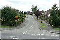
Rise Park Road
The western junction with Bestwood Park Drive West.
Image: © Alan Murray-Rust
Taken: 20 Jul 2010
0.03 miles
2
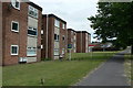
Oulton and Burnham Lodges
A small group of flat blocks in the Rise Park Estate.
Image: © Alan Murray-Rust
Taken: 20 Jul 2010
0.09 miles
3
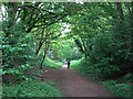
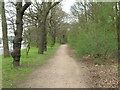
Footpath on the former Leen Valley Railway
The Great Northern Railway's Leen Valley line, built in 1881 to serve collieries in the Leen valley (and extended through Sutton in Ashfield to Langwith in 1898), ran directly ahead and behind the camera until closure in 1968. The Leen Valley line lost its regular passenger service as early as 1929.
Image: © John Sutton
Taken: 6 May 2011
0.11 miles
4
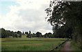
Bulwell Forest Vicinity, Nottingham
The junction of Hucknall Road (A611) and Bestwood Road (B683) lies two minutes walk behind the photographer. A 10-15 minute walk along this footpath brings walkers to the opposite end of Bestwood Road, near to the Bulwell Forest tram stop. The main feature of the picture is this part of Bulwell Forest public golf course with the club house just about visible on the hill in the distance, beyond which lies the city centre (as the crow flies). London and North Eastern Railway (LNER) Company railway tracks used to be situated to the right of the tall concrete posts.
Image: © David Hallam-Jones
Taken: 13 Sep 2013
0.12 miles
5
Benchmark on Bulwell Forest Golf Course triangulation pillar
Ordnance Survey flush bracket (serial identifier S4617) benchmark described on the Bench Mark Database at http://www.bench-marks.org.uk/bm6070
Image: © Roger Templeman
Taken: 28 Nov 2017
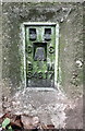
0.12 miles
7

Bulwell Forest Golf Course
There is an Ordnance Survey trig point pillar, http://trigpointing.uk/trig/3402 near the right hand edge of the image. The pillar has a flush bracket benchmark Image on the right hand face of the pillar.
Image: © Roger Templeman
Taken: 28 Nov 2017
0.12 miles
9
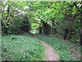
Path on old railway track
This line, jointly owned by the Great Central and Great Northern Railways, was built in 1898 to join the then new GCR main line at Bulwell Common and the existing GNR Leen Valley line; it also led to Bestwood Colliery. The line closed, along with the rest of the GC and GN lines north of Nottingham, in 1968 and the embankment now carries a footpath along the edge of Bulwell Forest Golf Club.
Image: © John Sutton
Taken: 6 May 2011
0.14 miles
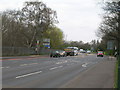
10
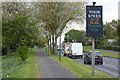
Speed indicator on Bestwood Park Drive West
Image: © David Lally
Taken: 27 Apr 2017
0.16 miles