IMAGES TAKEN NEAR TO
Brownlow Drive, NOTTINGHAM, NG5 5BD
Introduction
This page details the photographs taken nearby to Brownlow Drive, NG5 5BD by members of the Geograph project.
The Geograph project started in 2005 with the aim of publishing, organising and preserving representative images for every square kilometre of Great Britain, Ireland and the Isle of Man.

There are currently over 7.5m images from over14,400 individuals and you can help contribute to the project by visiting https://www.geograph.org.uk
Image Map
Images are licensed for reuse under creativecommons.org/licenses/by-sa/2.0
Notes
- Clicking on the map will re-center to the selected point.
- The higher the marker number, the further away the image location is from the centre of the postcode.
Image Listing (32 Images Found)
Images are licensed for reuse under creativecommons.org/licenses/by-sa/2.0
Image
Details
Distance
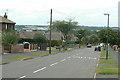
1
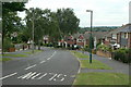
Brownlow Drive
This is the main distributor road in the northern section of Rise Park Estate. Looking west at Haverhill Crescent
Image: © Alan Murray-Rust
Taken: 20 Jul 2010
0.02 miles
2
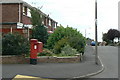
Haverhill Crescent postbox ref NG5 158
Standard EIIR pillar box with attached deliveries locker.
Image: © Alan Murray-Rust
Taken: 20 Jul 2010
0.07 miles
3
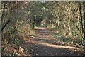
Route 6
NCN route 6 on the trackbed of the former Great Northern Leen Valley line
Image: © Richard Croft
Taken: 25 Nov 2011
0.12 miles
4
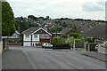
Colinwood Avenue
Looking across to the southern part of Rise Park.
Image: © Alan Murray-Rust
Taken: 20 Jul 2010
0.12 miles
5
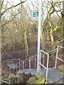
Little Oakwood Drive, Rise Park, Nottingham
A flight of steep steps that connect Little Oakwood Drive (off Brownlow Drive) with part of the former Leen Valley Railway track-bed. Houses on Bestwood Road are visible in the distance.
Image: © David Hallam-Jones
Taken: 24 Jan 2014
0.13 miles
6
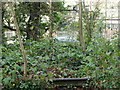
Leen Valley Walk, Bestwood, Notts.
An industrial unit on Bestwood Road (the B683) can be seen through the trees from the footpath/cycle track created on this former railway track-bed. There is even a piece of redundant rail track visible.
Image: © David Hallam-Jones
Taken: 24 Jan 2014
0.13 miles
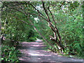
7
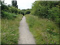
Cyclepath on Old Railway Embankment
This is part of the National Cycle Network Route 6 on the northern outskirts of Nottingham. Although it looks quite idyllic there is a constant hum of traffic from the road at the bottom of the embankment to the right of this photo.
Image: © Oxymoron
Taken: 10 Jul 2008
0.15 miles
8
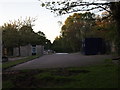
Nottingham - NG6 (Bestwood)
The demolition of the Bestwood Day Centre for individuals with learning disability-related needs seems almost complete. The B683 - Bestwood Road - runs parallel with the premises forecourt seen here (i.e. to the right of the pre-cast concrete fence immediately behind the demolition workers' metal storage container).
Image: © David Hallam-Jones
Taken: 16 May 2012
0.16 miles
9
Brownlow Drive
Looking west near Roseneath Avenue.
Image: © Alan Murray-Rust
Taken: 20 Jul 2010
0.18 miles
10
Former track of the Great Northern Leen Valley Line
The Great Northern Railway built this line to carry coal from the Leen Valley pits to its huge marshalling yards at Colwick, east of Nottingham. It opened in 1881, lost its passenger service in 1931 and closed completely in 1964. From Bulwell Forest to Bestwood it ran largely on a high embankment parallel to the road - now a traffic-free cycle route shaded by the trees and bushes which have grown tall since closure.
Image: © John Sutton
Taken: 13 Jul 2011
0.20 miles