IMAGES TAKEN NEAR TO
Lambourne Gardens, NOTTINGHAM, NG5 4PA
Introduction
This page details the photographs taken nearby to Lambourne Gardens, NG5 4PA by members of the Geograph project.
The Geograph project started in 2005 with the aim of publishing, organising and preserving representative images for every square kilometre of Great Britain, Ireland and the Isle of Man.

There are currently over 7.5m images from over14,400 individuals and you can help contribute to the project by visiting https://www.geograph.org.uk
Image Map
Images are licensed for reuse under creativecommons.org/licenses/by-sa/2.0
Notes
- Clicking on the map will re-center to the selected point.
- The higher the marker number, the further away the image location is from the centre of the postcode.
Image Listing (31 Images Found)
Images are licensed for reuse under creativecommons.org/licenses/by-sa/2.0
Image
Details
Distance
1
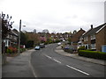
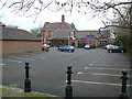
East end of Walsingham Road, Arno Vale
Image: © Richard Vince
Taken: 17 Apr 2014
0.11 miles
2
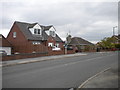
Site of Arno Vale bus turning circle (1)
The house with the pair of dormer windows was built on the site of the turning circle provided for Nottingham City Transport bus route 10, which terminated here. It was rendered redundant when the Arnold area services were reorganised around 1980, with the Arno Vale service being extended to Plains Estate and Arnold (much as today's routes 56 and 57 serve this area now). After being fenced off but still visible for many years, the site was developed for a small quantity of housing a few years ago.
Image: © Richard Vince
Taken: 17 Apr 2014
0.12 miles
3
Site of Arno Vale bus turning circle (2)
The house with the pair of dormer windows (right) was built on the site of the turning circle provided for Nottingham City Transport bus route 10, which terminated here. It was rendered redundant when the Arnold area services were reorganised around 1980, with the Arno Vale service being extended to Plains Estate and Arnold (much as today's routes 56 and 57 serve this area now). After being fenced off but still visible for many years, the site was developed for a small quantity of housing a few years ago.
Image: © Richard Vince
Taken: 17 Apr 2014
0.13 miles
4
Plains Road Vicinity, Mapperley, Notts.
This grand looking property, set back from Plains Road, seems likely to have been a residential property called "Tree Tops House". It is currently a restaurant. Old maps however, suggest that it might originally have been known as Arnold Mill House.
Image: © David Hallam-Jones
Taken: 1 Jan 2016
0.14 miles
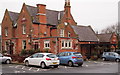
5
The Tree Tops
A large Victorian house on Mapperley Plains now converted into a pub/restaurant. The wing to the right of the building is a very recent addition
Image: © Alan Murray-Rust
Taken: 1 Feb 2009
0.15 miles
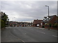
6
Somersby Road, Arnold, Notts.
With the first (or the last) 15% of the southern end of Somersby Road behind the photographer, this is panorama takes Daybrook, the central part of Arnold and beyond these, Redhill. In the centre of the photograph is a playing field used by both Arno Vale Junior School and Woodthorpe Infants School, which are situated on the east and west sides of the expanse.
Image: © David Hallam-Jones
Taken: 1 Jan 2016
0.17 miles
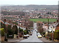
7

Down Somersby Road
There are long views from Mapperley Plains (over 125m/410ft). This slightly foreshortened shot towards Arnold, with the hills south of Annesley on the distant skyline, emphasises the steepness of Somersby Road.
Image: © John Sutton
Taken: 23 Jun 2014
0.17 miles
8
Housing on Whitby Crescent, Arno Vale
Image: © Richard Vince
Taken: 17 Apr 2014
0.17 miles
9

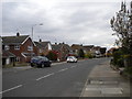
Somersby Road
The opposite direction to Image; the gradient is well obvious here.
Image: © Alan Murray-Rust
Taken: 1 Feb 2009
0.18 miles
10
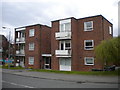
Nordean Court, Arno Vale
A block of low rise flats taking up almost the whole of the north west side of Nordean Road.
Image: © Richard Vince
Taken: 17 Apr 2014
0.18 miles