IMAGES TAKEN NEAR TO
Worcester Road, NOTTINGHAM, NG5 4HY
Introduction
This page details the photographs taken nearby to Worcester Road, NG5 4HY by members of the Geograph project.
The Geograph project started in 2005 with the aim of publishing, organising and preserving representative images for every square kilometre of Great Britain, Ireland and the Isle of Man.

There are currently over 7.5m images from over14,400 individuals and you can help contribute to the project by visiting https://www.geograph.org.uk
Image Map
Images are licensed for reuse under creativecommons.org/licenses/by-sa/2.0
Notes
- Clicking on the map will re-center to the selected point.
- The higher the marker number, the further away the image location is from the centre of the postcode.
Image Listing (59 Images Found)
Images are licensed for reuse under creativecommons.org/licenses/by-sa/2.0
Image
Details
Distance
1
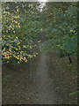
Old railway line
This was the old Great Northern Railway line from Nottingham to Derby via Ilkeston. It was a roundabout route for passengers, but resulted from the fundamental need for the carriage of coal from the Nottas and Derby coalfield. Today the railway alignment carries a footpath, seen here from the bridge carrying Thackerays Lane.
Image: © Alan Murray-Rust
Taken: 25 Oct 2009
0.10 miles
2
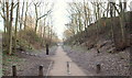
Arnot Hill Park, Daybrook, Notts.
The part of the route followed by the former Great Northern Railway Derbyshire Extension ("The Back Line") that ran from Netherfield & Colwick on the Grantham line to Derby via Kimberley and Ilkeston. The steps seen here rise to the top of the embankment and then, beyond it is the centre of Arnot Hill Park. This footpath and cycle route can also be accessed from Aylesham Avenue and from Greendale Road (both ahead). It seems that the line east of Daybrook was finally closed in April 1960 when Mapperley Tunnel was once again the subject of subsidence and repairs were deemed non-viable from an economical perspective.
Image: © David Hallam-Jones
Taken: 12 Jan 2014
0.10 miles
3

Five ways
Recreating this 'First' for the square http://www.geograph.org.uk/photo/18589
Image: © Alan Murray-Rust
Taken: 12 Aug 2021
0.10 miles
4

The Back Line
Now a footpath, this was once the Great Northern Railway line from Colwick to Derby, always known as The Back Line, busy carrying coal from the Erewash Valley and occasional Basford (via Gedling) local passenger trains, which began their journeys north by leaving from the south end of Nottingham Victoria and taking the Grantham line at Weekday Cross Junction (where the Nottingham Contemporary art gallery now is) before heading north then west from Netherfield & Colwick. The line closed east of Daybrook in April 1960 when Mapperley Tunnel, made unsafe by colliery subsidence, was deemed uneconomical to repair and maintain. Coal and empty ore trains were then diverted to the Great Central line through Victoria Station and reached Colwick from the west. The bridge carrying Thackerays Lane is beyond the cyclist.
Image: © John Sutton
Taken: 18 May 2010
0.10 miles
5
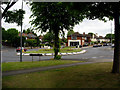
Five ways
Roundabout at junction of Thackerays Lane and Arno Vale Road.
Image: © Q
Taken: 14 Jun 2005
0.11 miles

7
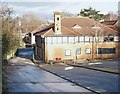
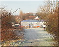
Arnot Hill Park Vicinity, Arnold, Notts.
A wing of Gedling Borough Council's Office complex seen from a footpath linking the "Go Sport" retail store car park - off Mansfield Road - with this area. Since the closure of Arnold Police Station in 2017 the local police contact point is now located within this building.
Image: © David Hallam-Jones
Taken: 26 Dec 2017
0.13 miles
8
Arnot Hill Park, Daybrook, Notts.
A westward view of the rear of the Mansfield Road B&Q DIY Store from the top of the 'frying pan handle end' of a remnant of a former railway embankment in Arnot Hill Park. The Great Northern Railway Derbyshire Extension ("The Back Line") ran from Netherfield & Colwick on the Grantham line to Derby via Kimberley and Ilkeston. The 'frying pan handle end' of the embankment continues behind the photographer until it eventually reaches a more substantial part of this public park and an entrance/exit into Arnot Hill Road.
Image: © David Hallam-Jones
Taken: 12 Jan 2014
0.13 miles
9
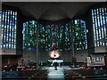
Interior, the Church of the Good Shepherd
An important milestone in the development of Catholic liturgy in the mid twentieth century. The church was designed by Gereard Goelen and the stained glass by Patrick Reyntiens https://historicengland.org.uk/listing/the-list/list-entry/1376603?section=official-list-entry
Image: © Jonathan Thacker
Taken: 3 Nov 2023
0.13 miles
10
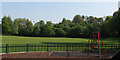
Woodthorpe Park - once a cricket ground
The small park behind The Vale public house at the corner of Mansfield Road and Thackerays Lane was once home to Woodthorpe Cricket Club, for which I played in the late 1960s. There is no sign of a wicket now, or of the tennis courts which restricted the width of the cricket field - which also had such short straight boundaries that it was only a delicate chip for a six into the garden of the club president, on Park Road, to the right. The trees in the background are growing on the embankment of the
short-lived Nottingham Suburban Railway, whose passenger service lasted only from 1889-1931, but which remained open until 1951 to serve Mapperley brickworks. It curved south from Daybrook Junction (just offstage left, where B&Q now stands) and passed through and under Woodthorpe Grange Park, serving stations at Sherwood and Thorneywood, before joining the Grantham line at Trent Lane Junction, trains terminating at London Road. Its course through Woodthorpe is marked by the curve of Worcester Road, while further south the almost appropriately-named Raibank Gardens is built on the trackbed.
Image: © John Sutton
Taken: 18 May 2010
0.14 miles