IMAGES TAKEN NEAR TO
Park Avenue, NOTTINGHAM, NG5 4HS
Introduction
This page details the photographs taken nearby to Park Avenue, NG5 4HS by members of the Geograph project.
The Geograph project started in 2005 with the aim of publishing, organising and preserving representative images for every square kilometre of Great Britain, Ireland and the Isle of Man.

There are currently over 7.5m images from over14,400 individuals and you can help contribute to the project by visiting https://www.geograph.org.uk
Image Map
Images are licensed for reuse under creativecommons.org/licenses/by-sa/2.0
Notes
- Clicking on the map will re-center to the selected point.
- The higher the marker number, the further away the image location is from the centre of the postcode.
Image Listing (68 Images Found)
Images are licensed for reuse under creativecommons.org/licenses/by-sa/2.0
Image
Details
Distance
1
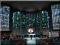
Interior, the Church of the Good Shepherd
An important milestone in the development of Catholic liturgy in the mid twentieth century. The church was designed by Gereard Goelen and the stained glass by Patrick Reyntiens https://historicengland.org.uk/listing/the-list/list-entry/1376603?section=official-list-entry
Image: © Jonathan Thacker
Taken: 3 Nov 2023
0.07 miles
2
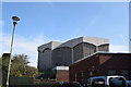
The Church of the Good Shepherd, Woodthorpe - rear view
A modern Catholic church, taken from the car park.
Image: © Trevor Harris
Taken: 20 Mar 2019
0.07 miles
3
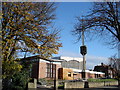
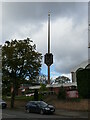
Catholic Church of the Good Shepherd, Nottingham
This ultra-modernist church makes an impressive statement; the detached spire-cum-bell tower [http://www.geograph.org.uk/photo/1042516] is especially striking.
Image: © Oxymoron
Taken: 12 Nov 2008
0.08 miles
4
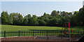
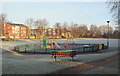
Woodthorpe Park - once a cricket ground
The small park behind The Vale public house at the corner of Mansfield Road and Thackerays Lane was once home to Woodthorpe Cricket Club, for which I played in the late 1960s. There is no sign of a wicket now, or of the tennis courts which restricted the width of the cricket field - which also had such short straight boundaries that it was only a delicate chip for a six into the garden of the club president, on Park Road, to the right. The trees in the background are growing on the embankment of the
short-lived Nottingham Suburban Railway, whose passenger service lasted only from 1889-1931, but which remained open until 1951 to serve Mapperley brickworks. It curved south from Daybrook Junction (just offstage left, where B&Q now stands) and passed through and under Woodthorpe Grange Park, serving stations at Sherwood and Thorneywood, before joining the Grantham line at Trent Lane Junction, trains terminating at London Road. Its course through Woodthorpe is marked by the curve of Worcester Road, while further south the almost appropriately-named Raibank Gardens is built on the trackbed.
Image: © John Sutton
Taken: 18 May 2010
0.08 miles
5
Catholic Church of the Good Shepherd, Nottingham
Image: © Oxymoron
Taken: 12 Nov 2008
0.08 miles
6
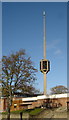
Spire, Church of the Good Shepherd, Arnold
Image: © Jonathan Thacker
Taken: 3 Nov 2023
0.09 miles
8

Five ways
Recreating this 'First' for the square http://www.geograph.org.uk/photo/18589
Image: © Alan Murray-Rust
Taken: 12 Aug 2021
0.11 miles
9
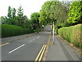
Thackeray's Lane, Arnold, Notts.
Thackeray's Lane Recreation Ground on a frosty morning. Thackeray's Lane, i.e. the A6211, lies outside the park's boundary railings behind the photographer. It seems likely the Thackeray mentioned here was Mr John L. Thackeray, an Alderman who resided in, and later rebuilt, a house called Arno Vale House. He owned cotton mills in the suburb of Radford and was the Mayor of Nottingham in both 1854 and 1856. He died in September 1886, aged 74 years.
Image: © David Hallam-Jones
Taken: 12 Jan 2014
0.11 miles
10
Arnot Hill Park, Daybrook, Notts.
A westward view of the rear of the Mansfield Road B&Q DIY Store from the top of the 'frying pan handle end' of a remnant of a former railway embankment in Arnot Hill Park. The Great Northern Railway Derbyshire Extension ("The Back Line") ran from Netherfield & Colwick on the Grantham line to Derby via Kimberley and Ilkeston. The 'frying pan handle end' of the embankment continues behind the photographer until it eventually reaches a more substantial part of this public park and an entrance/exit into Arnot Hill Road.
Image: © David Hallam-Jones
Taken: 12 Jan 2014
0.11 miles