IMAGES TAKEN NEAR TO
Wickstead Close, NOTTINGHAM, NG5 4HF
Introduction
This page details the photographs taken nearby to Wickstead Close, NG5 4HF by members of the Geograph project.
The Geograph project started in 2005 with the aim of publishing, organising and preserving representative images for every square kilometre of Great Britain, Ireland and the Isle of Man.

There are currently over 7.5m images from over14,400 individuals and you can help contribute to the project by visiting https://www.geograph.org.uk
Image Map
Images are licensed for reuse under creativecommons.org/licenses/by-sa/2.0
Notes
- Clicking on the map will re-center to the selected point.
- The higher the marker number, the further away the image location is from the centre of the postcode.
Image Listing (39 Images Found)
Images are licensed for reuse under creativecommons.org/licenses/by-sa/2.0
Image
Details
Distance
1
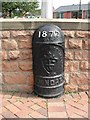
Boundary Marker
at the top of Woodthorpe Drive and marking the boundary between the City of Nottingham and Arnold Town
Image: © Tom Courtney
Taken: 18 Aug 2005
0.10 miles
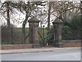
2
City Boundary
At the junction of Woodthorpe Drive and Woodborough Road. To the right is Nottingham to the left Arnold. The black boundary post is slightly left of centre.
Image: © Tom Courtney
Taken: 18 Aug 2005
0.10 miles
3
Bench Mark, Woodborough Road
On the wall surrounding Mapperley Reservoir.
Image: © Alan Murray-Rust
Taken: 30 Jul 2014
0.10 miles
4
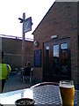
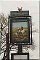
Bread & Bitter
Outside the Bread & Bitter in Mapperley, this was once a bakery but is now a pub run by the Castle Rock Brewery.
Image: © N Harrison
Taken: 29 Jul 2008
0.11 miles
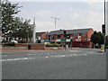
6
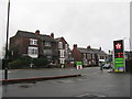
Houses on Woodborough Road
Suburban Nottingham from a petrol station. Looking across the B684.
Image: © M J Richardson
Taken: 2 Jan 2016
0.11 miles
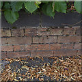
9
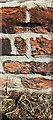
Benchmark on brick wall pier on north side of Woodborough Road
Ordnance Survey cut mark benchmark levelled at 128.205m above Newlyn Datum in 1962
Image: © Roger Templeman
Taken: 8 May 2022
0.12 miles
10
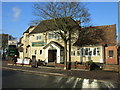
Mapperley
Visited all possible gates to this well guarded reservoir compound. Formerly joint UA Top for Nottingham but hill 5527 Nottingham M1 is now believed to be higher.
Name: Mapperley
Hill number: 5528
Height: 130m / 427ft
Area: 37: The River Tees to The Wash
Class: Un
Grid ref: SK 58790 43105
Summit feature: by reservoir gate
Drop: 18m
Col: 112m SK602449
Image: © Rude Health
Taken: 30 Jan 2011
0.12 miles