IMAGES TAKEN NEAR TO
Springwood Gardens, NOTTINGHAM, NG5 4HE
Introduction
This page details the photographs taken nearby to Springwood Gardens, NG5 4HE by members of the Geograph project.
The Geograph project started in 2005 with the aim of publishing, organising and preserving representative images for every square kilometre of Great Britain, Ireland and the Isle of Man.

There are currently over 7.5m images from over14,400 individuals and you can help contribute to the project by visiting https://www.geograph.org.uk
Image Map
Images are licensed for reuse under creativecommons.org/licenses/by-sa/2.0
Notes
- Clicking on the map will re-center to the selected point.
- The higher the marker number, the further away the image location is from the centre of the postcode.
Image Listing (48 Images Found)
Images are licensed for reuse under creativecommons.org/licenses/by-sa/2.0
Image
Details
Distance
1
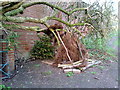
Den by Woodthorpe Grange
A bit of private construction behind the landscaped gardens.
Image: © Patrick
Taken: 20 Mar 2009
0.13 miles
2
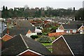
Former Mapperley Brickworks
Now covered by residential housing, in the sixties there were several ponds in this area resulting from the brick works where I used to collect newts.
Image: © Mick Garratt
Taken: 5 Jan 2007
0.14 miles
3
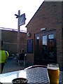
Bread & Bitter
Outside the Bread & Bitter in Mapperley, this was once a bakery but is now a pub run by the Castle Rock Brewery.
Image: © N Harrison
Taken: 29 Jul 2008
0.17 miles
4
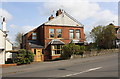
Nos. 65 and 67 Woodthorpe Drive
There is an Ordnance Survey benchmark Image on the side of the left hand house at the junction of the house and its porch extension
Image: © Luke Shaw
Taken: 1 Apr 2019
0.17 miles
5
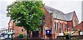
Mapperley Church on NW side of Woodborough Road
Image: © Roger Templeman
Taken: 10 May 2022
0.17 miles
6
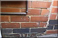
Benchmark on No. 65 Woodthorpe Drive
Ordnance Survey cut mark benchmark described on the Bench Mark Database at www.bench-marks.org.uk/bm44365
Image: © Luke Shaw
Taken: 1 Apr 2019
0.17 miles
7
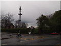
Nottingham - NG3
A cyclist peddling along Woodborough Road (B684) in the direction of Mapperley at the junction of Woodthorpe Road on a wet April afternoon. The Mapperley Ridge radio transmitter towers above everything else. Adjacent to the transmitter is a brick-built house belonging to the Severn-Trent Water Authority and behind the (now unused) gates the raised profile of a covered reservoir can be seen.
Image: © David Hallam-Jones
Taken: 20 Apr 2012
0.18 miles
8
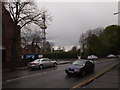
Nottingham - NG3
A view of part of Woodborough Road (B684) and its junction with Woodthorpe Road taken on a wet April afternoon. Features appearing include the corner of Mapperley Methodist Church and the Mapperley Ridge radio transmitter. Adjacent to the transmitter is a brick-built house belonging to the Severn-Trent Water Authority. Behind the "Caution Bumps Ahead" sign it is just possible to make out the raised profile of a covered reservoir.
Image: © David Hallam-Jones
Taken: 20 Apr 2012
0.18 miles
9
Nottingham, NG5 - Sherwood
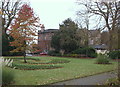
Woodthorpe Grange was built in 1874 as a family home for Henry Ashwell, a businessman in the bleaching, dyeing and finishing trade. In 1889, the Nottingham Suburban Railway was built running north to south across and under the estate. Although he was compensated, Ashwell didn't like this and he sold the grange to Edward Parry, who had designed the railway that split the estate. In 1905, Parry sold the estate to Godfrey Small, a Nottingham city councillor and then in 1921, Small sold the house to Nottingham City Council for £15,000 using a donation given by Sir Jesse Boot. The estate was opened to the public as Woodthorpe Grange Park in 1922. The house provides departmental offices for a Nottingham City Council.
Image: © David Hallam-Jones
Taken: 24 Nov 2012
0.18 miles
10
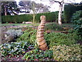
Woodthorpe Grange Park
Curious sculpture in the ornamental gardens.
Image: © Patrick
Taken: 20 Mar 2009
0.18 miles