IMAGES TAKEN NEAR TO
Mapperley Street, NOTTINGHAM, NG5 4DE
Introduction
This page details the photographs taken nearby to Mapperley Street, NG5 4DE by members of the Geograph project.
The Geograph project started in 2005 with the aim of publishing, organising and preserving representative images for every square kilometre of Great Britain, Ireland and the Isle of Man.

There are currently over 7.5m images from over14,400 individuals and you can help contribute to the project by visiting https://www.geograph.org.uk
Image Map
Images are licensed for reuse under creativecommons.org/licenses/by-sa/2.0
Notes
- Clicking on the map will re-center to the selected point.
- The higher the marker number, the further away the image location is from the centre of the postcode.
Image Listing (109 Images Found)
Images are licensed for reuse under creativecommons.org/licenses/by-sa/2.0
Image
Details
Distance
1
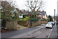
Looking west along Mapperley Street
There is an Ordnance Survey benchmark Image on the wall corner on the far side of the entrance drive on the left hand side of the street
Image: © Luke Shaw
Taken: 24 Apr 2020
0.01 miles
2
Spondon Street, Sherwood
A mixture of housing styles in Sherwood off Mansfield Road.
Image: © Alan Murray-Rust
Taken: 15 Mar 2009
0.02 miles
3
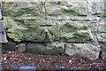
Benchmark on wall on south side of Mapperley Street
Ordnance Survey cut mark benchmark levelled at 80.059m above Newlyn Datum and verified in 1962
Image: © Luke Shaw
Taken: 24 Apr 2020
0.02 miles
4
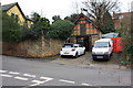
Garage of No.2 Mapperley Street on south side of the street
Ordnance Survey documents indicate that a benchmark levelled at 72.414m above Newlyn Datum on a wall in front of the garage was verified in 1962
Image: © Luke Shaw
Taken: 24 Apr 2020
0.04 miles
5
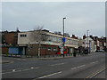
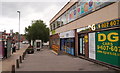
Sherwood Library
One of many suburban libraries in the City. The library occupies the upper floor, with some retail units underneath.
Image: © Alan Murray-Rust
Taken: 15 Mar 2009
0.06 miles
6
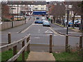
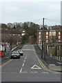
Nottingham - Sherwood NG5
A view of the lower section of a path that forms a short cut between Crich View and Mansfield Street. This very steep, ramp-like path can prove quite challenging for pedestrians during icy or snowy weather.
Having crossed Mansfield Street (on the other side of the posts and railings) Spondon St lies directly ahead with the A60 (Mansfield Rd) at its foot. The top floor of the rear of Sherwood library is visible - it is the light-pink coloured block in the lower left part of the picture.
Image: © David Hallam-Jones
Taken: 16 Mar 2012
0.07 miles
7
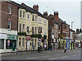
Punch and Judy
The pub has been created by merging two buildings, but they are of clearly different build, giving a very odd effect.
One of three traditional pubs close together in Sherwood on the east side of Mansfield Road. The others are Image and Image
Image: © Alan Murray-Rust
Taken: 15 Mar 2009
0.07 miles
8
The Robin Hood
One of three traditional pubs close together in Sherwood on the east side of Mansfield Road. The others are Image and Image
Image: © Alan Murray-Rust
Taken: 15 Mar 2009
0.08 miles
9
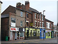
Sherwood, NG5, Nottingham.
On the right-hand side of Mansfield Road (the A60) the new - but as yet unopened -Police Office (or sub-station) is visible, together with the local library above it. Spondon Street branches off the A60, to the right, behind the tree.
Image: © David Hallam-Jones
Taken: 13 Jun 2013
0.08 miles
10
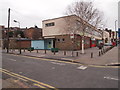
Nottingham - Sherwood NG5
A view of the Spondon St entrance to Sherwood library. The library occupies the top floor of the building and users looking out of its upper windows, visible in the picture, would look out onto Mansfield Rd (A60). The red painted shop on the ground floor is a defunct pizzeria and there are plans afoot to convert it into a part-time mini police station for Sherwood and Carrington in 2012/13.
Image: © David Hallam-Jones
Taken: 16 Mar 2012
0.08 miles