IMAGES TAKEN NEAR TO
Palm Cottages, NOTTINGHAM, NG5 4BG
Introduction
This page details the photographs taken nearby to Palm Cottages, NG5 4BG by members of the Geograph project.
The Geograph project started in 2005 with the aim of publishing, organising and preserving representative images for every square kilometre of Great Britain, Ireland and the Isle of Man.

There are currently over 7.5m images from over14,400 individuals and you can help contribute to the project by visiting https://www.geograph.org.uk
Image Map
Images are licensed for reuse under creativecommons.org/licenses/by-sa/2.0
Notes
- Clicking on the map will re-center to the selected point.
- The higher the marker number, the further away the image location is from the centre of the postcode.
Image Listing (93 Images Found)
Images are licensed for reuse under creativecommons.org/licenses/by-sa/2.0
Image
Details
Distance
1
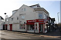
Sherwood, NG5, Nottingham.
Hall Street from the intersection with Mansfield Street. Mansfield Road (the A60) lies behind 30 seconds walk away behind the photographer.
Image: © David Hallam-Jones
Taken: 13 Jun 2013
0.04 miles
2
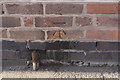
Benchmark on No. 6 Winchester Street
Ordnance Survey cut mark benchmark described on the Bench Mark Database at www.bench-marks.org.uk/bm114812
Image: © Luke Shaw
Taken: 1 Apr 2019
0.06 miles
3
Nos. 6 and 4 Winchester Street
There is an Ordnance Survey benchmark Image at the junction of the two houses
Image: © Luke Shaw
Taken: 1 Apr 2019
0.06 miles
4

Nottingham - Sherwood NG5
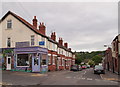
A view of some of the "Sherwood shops" on Mansfield Rd (A60) looking in the direction of the Winchester St/Newstead St crossroads. A mini street market is held on this wider-than-average stretch of pavement once a month .
Image: © David Hallam-Jones
Taken: 16 Mar 2012
0.07 miles
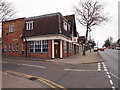
5
No. 664 Mansfield Road (Bargain Booze) at Hall Street junction
Ordnance Survey documents indicate that in 1962 a cut mark benchmark was levelled at 73.673m above Newlyn Datum on the building beside the Hall Street street name sign. The mark has been covered by render.
Image: © Luke Shaw
Taken: 1 Apr 2019
0.07 miles
6
Congested Street Scene in Sherwood
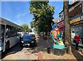
Mansfield Road on a weekday afternoon. Also visible here is one of the ‘Hoodwinked Owls’ currently on show across the city.
Image: © Jonathan Clitheroe
Taken: 9 Sep 2024
0.07 miles
7

Hi-Fi Shop on Mansfield Road
A branch of a nationwide chain which began, believe it or not, in Kent.
Image: © David Lally
Taken: 30 Dec 2009
0.07 miles
8
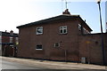
Nottingham - Sherwood NG5
A view of the A60 in the Mansfield direction. The now defunct police station at No.621 Mansfield Road can be seen on the left at the junction with Burlington Road. This station opened in October 2007 to provide a more visible local police presence. It was closed in 2011 as part of a national economy drive, although plans have been approved for the opening of a part-time mini police station on the Sherwood library site in 2012-13.
Image: © David Hallam-Jones
Taken: 16 Mar 2012
0.08 miles
9
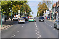
Mansfield Road, Sherwood
The A60 in the Sherwood district of Nottingham.
Image: © David Dixon
Taken: 13 Oct 2022
0.08 miles
10
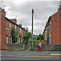
Sherwood: Winchester Terrace
Terraced houses with front gardens separated by an entry.
Image: © John Sutton
Taken: 17 Jun 2014
0.08 miles