IMAGES TAKEN NEAR TO
Ridsdale Road, NOTTINGHAM, NG5 3GR
Introduction
This page details the photographs taken nearby to Ridsdale Road, NG5 3GR by members of the Geograph project.
The Geograph project started in 2005 with the aim of publishing, organising and preserving representative images for every square kilometre of Great Britain, Ireland and the Isle of Man.

There are currently over 7.5m images from over14,400 individuals and you can help contribute to the project by visiting https://www.geograph.org.uk
Image Map
Images are licensed for reuse under creativecommons.org/licenses/by-sa/2.0
Notes
- Clicking on the map will re-center to the selected point.
- The higher the marker number, the further away the image location is from the centre of the postcode.
Image Listing (62 Images Found)
Images are licensed for reuse under creativecommons.org/licenses/by-sa/2.0
Image
Details
Distance
1
Bedale Road, 1949
This picture was taken by the then owner of the house, my uncle Harry Lees, a headmaster. It shows his mother, Helen, who had been widowed since the 1890s and lived with him until her death in the early 1950s. Compare this picture with Image
Image: © Sutton family album
Taken: Unknown
0.05 miles
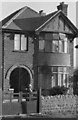
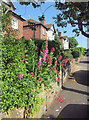
2
Bedale Road, 2013
Detached houses dating from the late 1930s and very typical of Nottingham's suburbs. Compare this picture with Image
Image: © John Sutton
Taken: 25 Jun 2013
0.06 miles
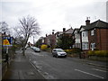
3
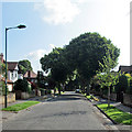
Daybrook: Ribblesdale Road
Looking towards the Mansfield Road end of Ribblesdale Road from near the corner of Mossdale Road.
Image: © John Sutton
Taken: 25 Jun 2013
0.09 miles
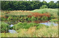
4
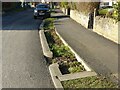
Rainwater garden, Ribblesdale Road
One of a series along the road. These small 'gardens' take the main run off from the road acting as natural filter beds and soakaways. They are planted with a variety of suitable plants, not very obviously so in this instance at this time of year. The gardens are intended to absorb run-off which otherwise would enter drains running into the Day Brook and which at times of heavy rain have resulted in the past in flooding of premises further downstream.
Image: © Alan Murray-Rust
Taken: 26 Jan 2022
0.10 miles
5

Rainwater garden, Ribblesdale Road
One of a series along the road. These small 'gardens' take the main run off from the road acting as natural filter beds and soakaways. They are planted with a variety of suitable plants, not very obviously so in this instance at this time of year. The gardens are intended to absorb run-off which otherwise would enter drains running into the Day Brook and which at times of heavy rain have resulted in the past in flooding of premises further downstream.
Image: © Alan Murray-Rust
Taken: 26 Jan 2022
0.10 miles
6
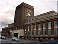
Home Brewery buildings, Daybrook
Now council offices
Image: © Q
Taken: 14 Jun 2005
0.10 miles
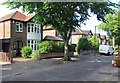
7
Daybrook: a summer morning in Ennerdale Road
Image: © John Sutton
Taken: 25 Jun 2013
0.11 miles
8
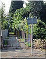
Ribblesdale Road: twitchel to Valley Road
The path crosses Day Brook and the recreation ground, next to the bowling green.
Image: © John Sutton
Taken: 25 Jun 2013
0.11 miles
10
Valley Road Park Flood Plain, Nottingham NG5
This long, thin, sausage-shaped park is known as Day Brook Recreation Ground at its other end. Here, at its Mansfield Road end it is called Valley Road Park. Nonetheless the footpath, seen here passing the Day Brook flood plain (or flood fringe), is actually an almost continuous path between the Valley Rd/Mansfield Rd junction entrance and its Edwards Lane exit. Valley Road (the A6514) runs behind the tree line directly ahead.
Image: © David Hallam-Jones
Taken: 12 Jul 2014
0.11 miles