IMAGES TAKEN NEAR TO
Danethorpe Vale, NOTTINGHAM, NG5 3ER
Introduction
This page details the photographs taken nearby to Danethorpe Vale, NG5 3ER by members of the Geograph project.
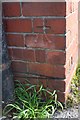
The Geograph project started in 2005 with the aim of publishing, organising and preserving representative images for every square kilometre of Great Britain, Ireland and the Isle of Man.

There are currently over 7.5m images from over14,400 individuals and you can help contribute to the project by visiting https://www.geograph.org.uk
Image Map
Images are licensed for reuse under creativecommons.org/licenses/by-sa/2.0
Notes
- Clicking on the map will re-center to the selected point.
- The higher the marker number, the further away the image location is from the centre of the postcode.
Image Listing (77 Images Found)
Images are licensed for reuse under creativecommons.org/licenses/by-sa/2.0
Image
Details
Distance
1
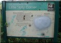
Little Holly Corner Nature Reserve - Information Board
Image: © Oxymoron
Taken: 17 Aug 2008
0.11 miles
2
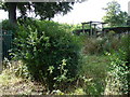
Little Holly Corner Nature Reserve
The smallest (about 100 square metres) nature reserve administered by the Wildlife Trusts.
Image: © Oxymoron
Taken: 17 Aug 2008
0.11 miles
3
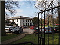
Nottingham - NG5
Woodthorpe House, Mansfield Rd, NG5. This Grade II listed building now functions as Sherwood Community Centre, having been in existence for a very long time. There appears to be evidence of its existence on a 1774 map by a cartographer called Carter. In WWII it was used as the Regimental H.Q. of the 161th Mixed Heavy A.A. Regiment when Nissen huts were erected in the grounds and a canteen was built on the site of the former loggia. The buildings were also used as a P.O.W camp. The building was acquired by Nottingham City Council in 1949 and has seen service as a school meals canteen and as an annexe to Haywood School.
Image: © David Hallam-Jones
Taken: 21 Mar 2012
0.11 miles
4
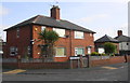
Nos. 24 and 22 Tithby Drive
There is an Ordnance Survey benchmark Image on the corner, left hand face, of the nearer house, right of a black downpipe
Image: © Luke Shaw
Taken: 1 Apr 2019
0.14 miles
5
Benchmark on No. 24 Tithby Drive
Ordnance Survey cut mark benchmark described on the Bench Mark Database at www.bench-marks.org.uk/bm114819
Image: © Luke Shaw
Taken: 1 Apr 2020
0.14 miles
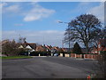
6
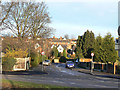
Danethorpe Vale
Leading up into Sherwood Estate from Valley Road.
Image: © Alan Murray-Rust
Taken: 8 Mar 2009
0.14 miles
8
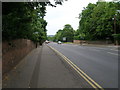
Nottingham - Sherwood
A view of the Edwards Lane roundabout with Mansfield Rd (A60) and the main Sherwood shopping area lying behind the photographer. In the foreground is a footpath that forms a thin, finger-like stretch of common land that sits in the centre of Edwards Lane.
Image: © David Hallam-Jones
Taken: 21 Mar 2012
0.15 miles
9
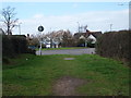
Nottingham - NG5
A view of the roundabout at the Mansfield Road end of Edwards Lane. A stationary car sits on a lower section of Edwards Lane. This busy bus route carries passengers and other traffic to & from the City Hospital and Valley Rd area of NG5. Behind the magnolia tree is a section of Perry Road leading in the direction of HMP Nottingham and Hucknall Rd (A611).
Image: © David Hallam-Jones
Taken: 21 Mar 2012
0.15 miles
10
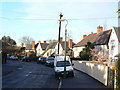
Montfort Crescent
The Sherwood Estate was a Nottingham City Council development of the 1930s. The general layout is attractive, but roads are well below standards for today's car-driven society.
Image: © Alan Murray-Rust
Taken: 8 Mar 2009
0.16 miles