IMAGES TAKEN NEAR TO
Edingley Square, NOTTINGHAM, NG5 3DU
Introduction
This page details the photographs taken nearby to Edingley Square, NG5 3DU by members of the Geograph project.
The Geograph project started in 2005 with the aim of publishing, organising and preserving representative images for every square kilometre of Great Britain, Ireland and the Isle of Man.

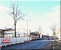
There are currently over 7.5m images from over14,400 individuals and you can help contribute to the project by visiting https://www.geograph.org.uk
Image Map
Images are licensed for reuse under creativecommons.org/licenses/by-sa/2.0
Notes
- Clicking on the map will re-center to the selected point.
- The higher the marker number, the further away the image location is from the centre of the postcode.
Image Listing (56 Images Found)
Images are licensed for reuse under creativecommons.org/licenses/by-sa/2.0
Image
Details
Distance
1
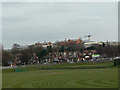
HM Prison, Nottingham
Seen from Tring Vale. As well as the traditional long blocks, there has been a significant amount of new build in recent years.
Image: © Alan Murray-Rust
Taken: 15 Mar 2009
0.13 miles
2
Nottingham - Bagthorpe
A view of the junction of Gunthorpe Drive with Perry Rd, NG5. On the left is part of HMP Nottingham that began life as Bagthorpe Gaol in 1890. It was rebuilt in 1912 and functioned as a closed training establishment for men until 1997. Its latest metamorphosis was in 2008 when it was reconstructed again and redoubled in size.
Image: © David Hallam-Jones
Taken: 21 Mar 2012
0.13 miles
3
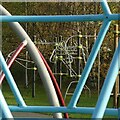
Tubular patterns
Climbing frames in Valley Road Park play area.
Image: © Alan Murray-Rust
Taken: 2 Dec 2022
0.14 miles
4
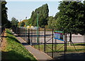
Bagthorpe, Valley Pk - NG5
Valley Road Park. This recreation ground is situated between the Day Brook, a river that acts as a natural boundary between City Hospital (on the right) and the A6514 (to the left of the railings). The series of lamp posts bordering Nottingham City Petanque Club’s pistes are a blast from the past having once provided external lighting on the P.Z. Cussons (U.K. Ltd) soap factory site in Basford. Gerard Bros Ltd opened a soap manufacturing factory in 1893 that was taken over by Cussons Ltd in 1955. The Cussons closed the factory in 2009, having decided to shift its production elsewhere and one of the founding members of the petanque club asked if the club might have the lamp posts as an alternative to them ending up as scrap metal. A couple of pictures of the posts in their former location can be seen on http://www.28dayslater.co.uk/forums/showthread.php/54919-PZ-Cussons-Nottingham-Oct-10.
Image: © David Hallam-Jones
Taken: 15 Sep 2012
0.15 miles
5
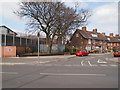
Perry Road, Nottingham, NG5
Perry Road connects Sherwood with Basford. This is a view towards the point where this road crosses the A611, i.e. Hucknall Road. The boundary wall of H.M.P. Nottingham is seen on the right, with a former Factory and Warehouse site on the left. The prison was closed in 1930 and reopened as a borstal in 1932. In 1950 it reverted to being a maximum security prison. New houses are currently being constructed on upon the area on the left, identified on a 1912 map as "Sherwood (Bleaching, Dyeing and Dressing) Works. These Works later became a factory and warehouse but the site was cleared in 2009-10 and the plot has stood unused until now. The buildings further along the road - that house a veterinary surgery - are identified on this same 1912 map as "Peace Mills", a title that has been selected as the name of this new development.
Image: © David Hallam-Jones
Taken: 26 Dec 2017
0.15 miles
6

Valley Road Park ? skate park ? 1
Skate parks are one of the few places where graffiti are accepted as part of the culture.
Image: © Alan Murray-Rust
Taken: 18 Jan 2022
0.15 miles
7

Valley Road Park ? bullet proof
Graffiti on the skate park. Deliberately underexposed to offset the sunshine reflecting off the silver paint.
Image: © Alan Murray-Rust
Taken: 18 Jan 2022
0.15 miles
8
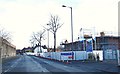
Perry Road, Nottingham, NG5
Perry Road connects Sherwood and Basford. This is a view towards the junction with Victoria Road (next right hand turning). The boundary wall of H.M.P. Nottingham is seen on the left, with a former Factory and Warehouse site on the left. The prison was closed in 1930 and reopened as a borstal in 1932. In 1950 it reverted to being a maximum security prison. New houses are currently being constructed on the left on a site identified on a 1912 map as the "Sherwood (Bleaching, Dyeing and Dressing) Works. Although the premises later became a factory and warehouse the site was cleared in 2009-10 and the plot left unused until now. Behind the photographer are some other older buildings identified on this same 1912 map as "Peace Mills", a title that has been selected as the name of this new housing development.
Image: © David Hallam-Jones
Taken: 26 Dec 2017
0.16 miles
9

Valley Road Park ? skate park ? 2
Skate parks are one of the few places where graffiti are accepted as part of the culture.
Image: © Alan Murray-Rust
Taken: 18 Jan 2022
0.16 miles
10
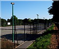
Bagthorpe, Valley Pk - NG5
Valley Road Park. This recreation ground is situated between the Day Brook, a river that acts as a natural boundary between City Hospital (out of sight, on the left) and the A6514 (to the right of the railings). The series of lamp posts bordering Nottingham City Petanque Club’s pistes are a blast from the past having once provided external lighting on the P.Z. Cussons (U.K. Ltd) soap factory site in Basford. Gerard Bros Ltd opened a soap manufacturing factory in 1893 that was taken over by Cussons Ltd in 1955. The Cussons closed the factory 2009, having decided to shift its production elsewhere and one of the founding members of the petanque club asked if the club might have the lamp posts as an alternative to them ending up as scrap metal. A couple of pictures of the posts in their former location can be seen on http://www.28dayslater.co.uk/forums/showthread.php/54919-PZ-Cussons-Nottingham-Oct-10
Image: © David Hallam-Jones
Taken: 15 Sep 2012
0.16 miles