IMAGES TAKEN NEAR TO
Compton Road, NOTTINGHAM, NG5 2NJ
Introduction
This page details the photographs taken nearby to Compton Road, NG5 2NJ by members of the Geograph project.
The Geograph project started in 2005 with the aim of publishing, organising and preserving representative images for every square kilometre of Great Britain, Ireland and the Isle of Man.

There are currently over 7.5m images from over14,400 individuals and you can help contribute to the project by visiting https://www.geograph.org.uk
Image Map
Images are licensed for reuse under creativecommons.org/licenses/by-sa/2.0
Notes
- Clicking on the map will re-center to the selected point.
- The higher the marker number, the further away the image location is from the centre of the postcode.
Image Listing (68 Images Found)
Images are licensed for reuse under creativecommons.org/licenses/by-sa/2.0
Image
Details
Distance
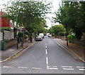
1

Perry Road, Sherwood
Completely deserted on a Sunday Morning. The appropriately grim concrete curtain wall on the left is part of Nottingham prison, and the low brick building on the right, now boarded up, used to house an engineering works.
Image: © Oxymoron
Taken: 17 Aug 2008
0.07 miles
2
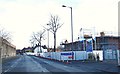
Perry Road, Nottingham, NG5
Perry Road connects Sherwood and Basford. This is a view towards the junction with Victoria Road (next right hand turning). The boundary wall of H.M.P. Nottingham is seen on the left, with a former Factory and Warehouse site on the left. The prison was closed in 1930 and reopened as a borstal in 1932. In 1950 it reverted to being a maximum security prison. New houses are currently being constructed on the left on a site identified on a 1912 map as the "Sherwood (Bleaching, Dyeing and Dressing) Works. Although the premises later became a factory and warehouse the site was cleared in 2009-10 and the plot left unused until now. Behind the photographer are some other older buildings identified on this same 1912 map as "Peace Mills", a title that has been selected as the name of this new housing development.
Image: © David Hallam-Jones
Taken: 26 Dec 2017
0.08 miles
3
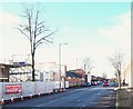
Perry Road, Nottingham, NG5
Perry Road connects Sherwood with Basford. This is a view towards the point where this road crosses the A611, i.e. Hucknall Road. The boundary wall of H.M.P. Nottingham is seen on the right, with a former Factory and Warehouse site on the left. The prison was closed in 1930 and reopened as a borstal in 1932. In 1950 it reverted to being a maximum security prison. New houses are currently being constructed on upon the area on the left, identified on a 1912 map as "Sherwood (Bleaching, Dyeing and Dressing) Works. These Works later became a factory and warehouse but the site was cleared in 2009-10 and the plot has stood unused until now. The buildings further along the road - that house a veterinary surgery - are identified on this same 1912 map as "Peace Mills", a title that has been selected as the name of this new development.
Image: © David Hallam-Jones
Taken: 26 Dec 2017
0.08 miles
4
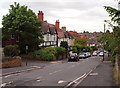
Sherwood NG5, Nottingham.
With Perry Road 200 metres (220 yds) further up the hill, behind the photographer, this is view down Victoria Road towards Haydn Road, with Rufford Road branching off on the left. Rufford Road is a cul-de-sac, although there is a twitchell - an alleyway - for pedestrians that connects it to Woodville Drive.(The word "twychel" dates back to the C15th).
Image: © David Hallam-Jones
Taken: 13 Jun 2013
0.09 miles
5
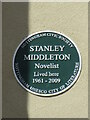
Plaque to Stanley Middleton
On right hand side of front of 42 Caledon Road. Celebrating the centenary of the birth of the author who was joint winner of the Booker Prize in 1974 with "Holiday".
Image: © El Loco
Taken: 7 Apr 2021
0.10 miles
6
Sherwood NG5, Nottingham.
Rufford Road from Victoria Street. There is a twitchell - an alleyway - at the other end of this cul-de-sac that connects this road with Woodville Drive. (The word "twychel" dates back to the C15th).
Image: © David Hallam-Jones
Taken: 13 Jun 2013
0.10 miles
7
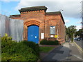
Nottingham Prison entrance
The old entrance to Nottingham Prison, which is undergoing major rebuilding work. To the right of the gate is the long, high wall which can be seen more clearly in Oxymoron's picture:-Image
Image: © Tony Bacon
Taken: 28 Aug 2008
0.10 miles
8
Nottingham Prison
Recreating this 'First' for the square https://www.geograph.org.uk/photo/18537 . The Victorian buildings have been replaced with more modern buildings. I decided not to get quite as close with a camera as the original photographer did.
Image: © Alan Murray-Rust
Taken: 20 Jul 2021
0.11 miles
9
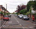
Sherwood NG5, Nottingham.
Hucknall Road (the A611) is situated at the other end of Caledon Road, the full length of which is seen here from its junction with Victoria Street.
Image: © David Hallam-Jones
Taken: 13 Jun 2013
0.11 miles
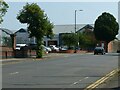
10
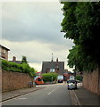
Bagthorpe NG5, Nottingham.
Hucknall Road (the A611) seen here from Compton Road. The bus is less than 100 yds away from Perry Road crossroads. H.M.Prison Nottingham, once known as Bagthorpe Gaol, is situated in Perry Road.
Image: © David Hallam-Jones
Taken: 13 Jun 2013
0.11 miles