IMAGES TAKEN NEAR TO
Mansfield Road, NOTTINGHAM, NG5 2BU
Introduction
This page details the photographs taken nearby to Mansfield Road, NG5 2BU by members of the Geograph project.
The Geograph project started in 2005 with the aim of publishing, organising and preserving representative images for every square kilometre of Great Britain, Ireland and the Isle of Man.

There are currently over 7.5m images from over14,400 individuals and you can help contribute to the project by visiting https://www.geograph.org.uk
Image Map
Images are licensed for reuse under creativecommons.org/licenses/by-sa/2.0
Notes
- Clicking on the map will re-center to the selected point.
- The higher the marker number, the further away the image location is from the centre of the postcode.
Image Listing (320 Images Found)
Images are licensed for reuse under creativecommons.org/licenses/by-sa/2.0
Image
Details
Distance
1

Here be dragons!
A magnificent corbel on the bay window of 212 Mansfield Road https://www.geograph.org.uk/photo/7353566 .
Image: © Alan Murray-Rust
Taken: 27 Nov 2022
0.01 miles
2
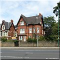
208 Mansfield Road
A Watson Fothergill house from 1893.
Now proved to be by a Joseph Wright - see page 180 of Fothergill by Darren Turner.
Image: © David Lally
Taken: 6 May 2010
0.02 miles
3

212 Mansfield Road, Nottingham
Late Victorian house with fine dragon corbels https://www.geograph.org.uk/photo/7353557 to the left hand window bay.
Image: © Alan Murray-Rust
Taken: 27 Nov 2022
0.02 miles
4
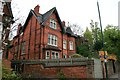
208 Mansfield Road, Nottingham
Late Victorian villa, thought at one stage to have been the work of Nottingham architect Watson Fothergill. The style is very similar, but Darren Taylor's catalogue of Fothergill's work has established that it was by Joseph Wright of Nottingham, the plans dated 1888 being held in the Nottinghamshire County Archive. Listed Grade II.
Detailed information about the hole in the wall in front of the house can be found here https://www.geograph.org.uk/photo/1823316
Image: © Alan Murray-Rust
Taken: 12 Aug 2019
0.03 miles
5
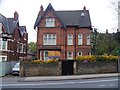
208 Mansfield Road
This red brick house was built circa 1893 and is listed, grade II, with details at: https://www.historicengland.org.uk/listing/the-list/list-entry/1254762
Image: © Michael Dibb
Taken: 31 Mar 2017
0.03 miles
6
Wyndham Mews
Off St Andrew's Road, on the edge of Mapperley Park. St Andrew's Church spire shows on the skyline
Image: © John Sutton
Taken: 6 Jul 2015
0.03 miles
7
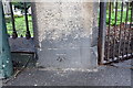
Benchmark on Mansfied Road cemetery wall pier
Ordnance Survey cut mark benchmark described on the Bench Mark Database at http://www.bench-marks.org.uk/bm42607
Image: © Roger Templeman
Taken: 9 Apr 2012
0.03 miles
8
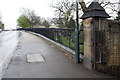
Cemetery boundary wall, Mansfield Road
There is an OS benchmark Image at the base of the wall pier at the right hand side of the image
Image: © Roger Templeman
Taken: 9 Apr 2012
0.03 miles
9
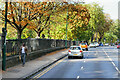
Mansfield Road, Nottingham
The A60 (Mansfield Road) passing the city's Rock Cemetery.
Image: © David Dixon
Taken: 13 Oct 2022
0.04 miles
10
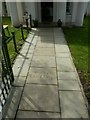
Forest Lodge, Nottingham
Entrance pathway with inscriptions referring to the 2013 restoration, see http://www.geograph.org.uk/photo/6239389 .
Image: © Alan Murray-Rust
Taken: 12 Aug 2019
0.04 miles