IMAGES TAKEN NEAR TO
Emperor Close, NOTTINGHAM, NG5 1QR
Introduction
This page details the photographs taken nearby to Emperor Close, NG5 1QR by members of the Geograph project.
The Geograph project started in 2005 with the aim of publishing, organising and preserving representative images for every square kilometre of Great Britain, Ireland and the Isle of Man.

There are currently over 7.5m images from over14,400 individuals and you can help contribute to the project by visiting https://www.geograph.org.uk
Image Map
Images are licensed for reuse under creativecommons.org/licenses/by-sa/2.0
Notes
- Clicking on the map will re-center to the selected point.
- The higher the marker number, the further away the image location is from the centre of the postcode.
Image Listing (101 Images Found)
Images are licensed for reuse under creativecommons.org/licenses/by-sa/2.0
Image
Details
Distance
1
Benchmark on #25 Teesdale Road
Ordnance Survey cut mark benchmark described on the Bench Mark Database at http://www.bench-marks.org.uk/bm35162.
Image: © Roger Templeman
Taken: 10 Aug 2010
0.07 miles
2

Benchmark on side of #46 Teesdale Road
Ordnance Survey cut mark benchmark described on the Bench Mark Database at http://www.bench-marks.org.uk/bm35163.
Image: © Roger Templeman
Taken: 10 Aug 2010
0.07 miles
3
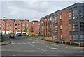
Hucknall Road: new housing on the Forman's site
The Thomas Forman printing factory was built in 1926 and closed in 1998. The site, which was large and included a sports ground, has been developed as housing. The streets are named for printers and typefounders, or after things connected with printing and stationery: Caxton Road (ahead), Plantin Road and Jensen Way, Ledger Walk, Parchment Mews and Serif Close. The neo-classical frontage of the factory on Hucknall Road remains, to the left of this viewpoint.
Image: © John Sutton
Taken: 27 Apr 2011
0.10 miles
5
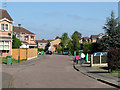
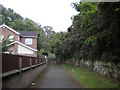
Camelot Avenue, New Basford
It is hard to believe there was once a main line railway here. Camelot Avenue is built on the site of the passenger and goods stations at New Basford. The goods sidings were to the left and the island-platform passenger station straight ahead.
The Great Central Railway main line from London Marylebone to Sheffield via Leicester and Nottingham was the last trunk route to be completed (1899) and the first to close (1967). North of Nottingham and in the city much of its route has disappeared - embankments flattened, cuttings filled, viaducts demolished - and it is hard to follow. After passing through the 665-yard Sherwood Rise Tunnel northbound trains entered a deep cutting in the sandstone (behind the camera). The cutting has now been filled in - see Image
Image: © John Sutton
Taken: 28 Apr 2011
0.11 miles
6
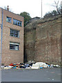
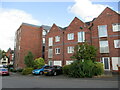
Corner of industrial estate
Some newer buildings (behind the photographer) have been built on an area that was previously occupied by a larger factory. The Bunter Sandstone behind is soft enough to excavate economically.
Image: © Alan Murray-Rust
Taken: 15 Mar 2009
0.11 miles
7
Nottingham - NG5 (Basford)
The footpath that commences at the end of this cul-de-sac (Camelot Avenue) leads to a sandstone cutting that previously carried the Great Central Railway main line towards New Basford station. The station was situated half a mile or so behind the photographer, off Haydn Road. The railway line, having come out of the Sherwood Rise tunnel, used to run to the left of these houses. The station itself (no longer in existence) was of the "island" type with the central ‘pad’ and its platforms located between the up and the down tracks. In this case however, the former station was apparently situated on a raised embankment, meaning that the station was accessed from a subterranean roadway or passageway off Haydn Road that passed beneath the lines. This section of the line closed completely on 25 March 1968
Image: © David Hallam-Jones
Taken: 23 May 2012
0.12 miles
8
Benchmark on Tesco Express, Hucknall Road
Ordnance Survey cut mark benchmark described on the Bench Mark Database at http://www.bench-marks.org.uk/bm35160.
Image: © Roger Templeman
Taken: 10 Aug 2010
0.12 miles
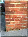
9

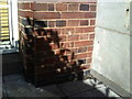
North end of The Atrium, Hucknall Road
There is an OS benchmark Image near the bottom of the brick column near the centre of the image
Image: © Roger Templeman
Taken: 9 Apr 2012
0.12 miles
10
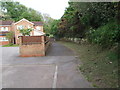
Footpath just beyond Camelot Avenue
The north end of the footpath seen in Image leads initially from the end of Camelot Avenue past the southernmost houses reached from that road to a gate that gives access to a small open space.
Image: © Richard Vince
Taken: 9 Jun 2012
0.12 miles