IMAGES TAKEN NEAR TO
Billesdon Drive, NOTTINGHAM, NG5 1NT
Introduction
This page details the photographs taken nearby to Billesdon Drive, NG5 1NT by members of the Geograph project.
The Geograph project started in 2005 with the aim of publishing, organising and preserving representative images for every square kilometre of Great Britain, Ireland and the Isle of Man.

There are currently over 7.5m images from over14,400 individuals and you can help contribute to the project by visiting https://www.geograph.org.uk
Image Map
Images are licensed for reuse under creativecommons.org/licenses/by-sa/2.0
Notes
- Clicking on the map will re-center to the selected point.
- The higher the marker number, the further away the image location is from the centre of the postcode.
Image Listing (29 Images Found)
Images are licensed for reuse under creativecommons.org/licenses/by-sa/2.0
Image
Details
Distance
1
Fenton Road : railway remains
The trees to the right are growing on the remains of the Great Central Railway embankment. Beyond them, the embankment - 40ft high where the railway crossed Valley Road on its way south to Nottingham Victoria - has been levelled and the houses of Tunstall Drive built. Fenton Road follows the course of Bagthorpe East Curve, which brought trains from the Great Northern Derby Friargate line to join the GC at Bagthorpe Junction (which was just north of Valley Road bridge, way above the roofs of the present houses, and those on Harmston Rise and Heatherley Avenue, whose alignments follow the bottom of the former embankment). In railway days the downward slope straight ahead was a single railway line rising to meet the main line. To the right of the houses in the distance on the left of the picture, the railway passed through the cutting in the sandstone ridge shown in my Image
Image: © John Sutton
Taken: 21 Jun 2011
0.09 miles
2
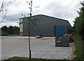
Factory unit on the former Great Central main line
The main line from Nottingham Victoria to Sheffield and Manchester ran straight ahead - the right wall of the modern factory is parallel to the former tracks. Bagthorpe East curve, carrying Derby Friargate trains to Basford North and on to Kimberley and Ilkeston, passed to the left of this building, where the bushes are. Behind the camera the embankment - 40ft high where it crossed the ring road - has been levelled and the houses of Tunstall Drive built. For more about the railway network in these parts, see Image], Image], Image] and others.
Image: © John Sutton
Taken: 21 Jun 2011
0.14 miles
3
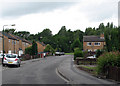
Tunstall Drive: once a railway embankment
Tunstall Drive is built where the Great Central Railway main line from Nottingham Victoria to Sheffield and Manchester once ran - on the top of an embankment in the region of 40ft above the present road level. The trees in the background grow on the slope of the truncated embankment and give an idea of how wide the earthworks were. Bagthorpe Junction and its signal box once stood roughly where I stood to take this picture, but a long way above my head. The scene at the top of what remains of the embankment is shown in Image], and for more about the railway network in these parts, see Image], Image], Image] and others.
Image: © John Sutton
Taken: 21 Jun 2011
0.15 miles
4
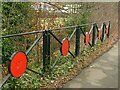
Roadside railings, Hucknall Road
Installed as part of the Hucknall Road Walkway which runs in the background. It has various wildlife and associated motifs.
Image: © Alan Murray-Rust
Taken: 8 Feb 2022
0.18 miles
5
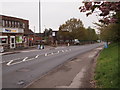
Nottingham - NG6
Arnold Road (B6004) is joined beyond the supermarket by Heathfield Road (named after of its association with Bagthorpe Isolation Hospital that later became Heathfield Hospital perhaps). The supermarket opened in 2011 in what was previously "The Heathfield" pub. Traffic travelling down this road ultimately reaches the David Lane tram stop.
Image: © David Hallam-Jones
Taken: 4 May 2012
0.19 miles
6
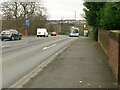
Hucknall Road, former railway bridge
The bridge crossed the former Great Northern Railway's Derbyshire Extensions line, known as the 'Back Line'.
There is a benchmark https://www.geograph.org.uk/photo/7107260 on the near parapet abutment.
Image: © Alan Murray-Rust
Taken: 8 Feb 2022
0.19 miles
7
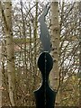
Hucknall Road Walkway marker ? rabbit
Alongside Hucknall Road at the southern end of the Walkway.
Image: © Alan Murray-Rust
Taken: 8 Feb 2022
0.19 miles
8
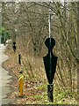
Hucknall Road Walkway markers
Alongside Hucknall Road at the southern end of the Walkway.
Image: © Alan Murray-Rust
Taken: 8 Feb 2022
0.19 miles
9

Bench Mark, Hucknall Road, former railway bridge
See https://www.geograph.org.uk/photo/7107264 for location.
Image: © Alan Murray-Rust
Taken: 8 Feb 2022
0.19 miles
10
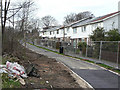
Foot- and cycleway improvement.
Part of the development of a linear walkway along the old GNR Leen Valley railway.
Image: © Alan Murray-Rust
Taken: 15 Mar 2009
0.19 miles