IMAGES TAKEN NEAR TO
Valley Road, NOTTINGHAM, NG5 1HN
Introduction
This page details the photographs taken nearby to Valley Road, NG5 1HN by members of the Geograph project.
The Geograph project started in 2005 with the aim of publishing, organising and preserving representative images for every square kilometre of Great Britain, Ireland and the Isle of Man.

There are currently over 7.5m images from over14,400 individuals and you can help contribute to the project by visiting https://www.geograph.org.uk
Image Map
Images are licensed for reuse under creativecommons.org/licenses/by-sa/2.0
Notes
- Clicking on the map will re-center to the selected point.
- The higher the marker number, the further away the image location is from the centre of the postcode.
Image Listing (61 Images Found)
Images are licensed for reuse under creativecommons.org/licenses/by-sa/2.0
Image
Details
Distance
1
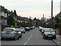
Valmont Road
Tween-wars housing off Hucknall Road.
Image: © Alan Murray-Rust
Taken: 15 Mar 2009
0.07 miles
2
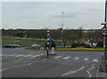
Roundabout at Valley Road
The crossing with Hucknall Road. A place to avoid at peak times with heavy flows on both Ring Road and Hucknall Road.
Image: © Alan Murray-Rust
Taken: 15 Mar 2009
0.09 miles
3
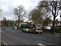
Bus ascending Hucknall Road (3)
Another member of the procession of buses using Hucknall Road, this one has originated only a short distance away on Bestwood estate. It has just crossed Valley Road, part of Nottingham's ring road, which is visible in the distance on the left. The inter war semi detached housing on the right is typical of this area; Hucknall Road was not served by trams, so this part of it was not developed for housing until later than nearby stretches of Nottingham Road and Mansfield Road.
Image: © Richard Vince
Taken: 23 Apr 2012
0.09 miles
4
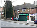
Hucknall Road Post Office
Still in business, with a GR pillar box, now missing its Post Office sign.
Image: © Alan Murray-Rust
Taken: 15 Mar 2009
0.09 miles
5
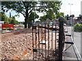
Valley Road, Nottingham NG5
As part of the road widening element of the Valley Road redevelopment project currently affecting "the City Hospital roundabout" area this former entrance gate into the meadow between the Day Brook (river) and Valley Road (A6514) is all that remains of the boundary fence. A section of the new boundary fence can be seen beneath the tall tree on the left, as can the temporary construction site base occupying the meadow.
Image: © David Hallam-Jones
Taken: 23 Aug 2014
0.10 miles
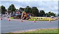
6

Nottingham - Bagthorpe
This roundabout carries the A611 Nottingham to Hucknall across Valley Rd. The boundary wall of The City Hospital can be seen on the right and beyond the bus, the Nottingham High School sports ground. Bagthorpe Workhouse, that was eventually amalgamated with The City Hospital would have been inside the boundary wall referred to in this picture.
Image: © David Hallam-Jones
Taken: 10 Mar 2012
0.10 miles
7
Valley Road, Nottingham NG5
Alterations in progress to "The City Hospital roundabout" as part of a Hucknall Road/Valley Road redevelopment project.
Image: © David Hallam-Jones
Taken: 23 Aug 2014
0.10 miles
8
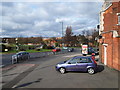
Nottingham - Bagthorpe
Part of the long established shopping centre that has developed around the Hucknall Rd/Valley Rd roundabout near to The City Hospital - seen beyond the tree line. This part of Nottingham lies in Sherwood (local government) Ward.
Image: © David Hallam-Jones
Taken: 10 Mar 2012
0.11 miles
9
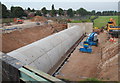
Valley Road, Nottingham NG5
A pre-cast concrete conduit built to carry the Day Brook beneath the redeveloped Hucknall Road (A611)/Valley Road (the A6514) roundabout. The brook passes through Nottingham High School's playing field. The school's tennis courts are visible, sandwiched between the cricket field and Valley Road. The roundabout and the boundary of City Hospital are situated behind the photographer.
Image: © David Hallam-Jones
Taken: 12 Jul 2014
0.11 miles
10

Bus ascending Hucknall Road (2)
A bus operating service L14, one of the more leisurely ways to travel from Bulwell to Nottingham city centre, climbs past some fairly modern housing a little way south of Hucknall Road's junction with Valley Road. On the left, some of the City Hospital can be glimpsed in the distance.
Image: © Richard Vince
Taken: 23 Apr 2012
0.11 miles