IMAGES TAKEN NEAR TO
Hill Crest Grove, NOTTINGHAM, NG5 1FT
Introduction
This page details the photographs taken nearby to Hill Crest Grove, NG5 1FT by members of the Geograph project.
The Geograph project started in 2005 with the aim of publishing, organising and preserving representative images for every square kilometre of Great Britain, Ireland and the Isle of Man.

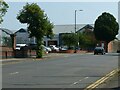
There are currently over 7.5m images from over14,400 individuals and you can help contribute to the project by visiting https://www.geograph.org.uk
Image Map
Images are licensed for reuse under creativecommons.org/licenses/by-sa/2.0
Notes
- Clicking on the map will re-center to the selected point.
- The higher the marker number, the further away the image location is from the centre of the postcode.
Image Listing (62 Images Found)
Images are licensed for reuse under creativecommons.org/licenses/by-sa/2.0
Image
Details
Distance
1
Nottingham Prison
Recreating this 'First' for the square https://www.geograph.org.uk/photo/18537 . The Victorian buildings have been replaced with more modern buildings. I decided not to get quite as close with a camera as the original photographer did.
Image: © Alan Murray-Rust
Taken: 20 Jul 2021
0.04 miles
2
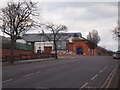
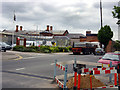
Nottingham - Bagthorpe
A view along Perry Rd in the direction of Sherwood with HMP Nottingham on left-hand side. His Majesty's Prison was opened in 1891 for the reception of 206 males and 31 females.
Image: © David Hallam-Jones
Taken: 10 Mar 2012
0.04 miles
3
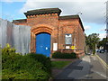
Nottingham Prison entrance
The old entrance to Nottingham Prison, which is undergoing major rebuilding work. To the right of the gate is the long, high wall which can be seen more clearly in Oxymoron's picture:-Image
Image: © Tony Bacon
Taken: 28 Aug 2008
0.05 miles
4
Nottingham - Bagthorpe
An unusable ancillary road forming a physical boundary between HMP Nottingham and Perry Road (Sherwood direction). The prison was known as Bagthorpe Gaol in the past.
Image: © David Hallam-Jones
Taken: 10 Mar 2012
0.06 miles
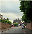
5
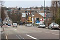
Hucknall Road
Looking towards the city
Image: © Mick Garratt
Taken: 29 Mar 2008
0.06 miles
6
Nottingham Prison
Building work at Nottingham Prison
Image: © Q
Taken: 14 Jun 2005
0.07 miles
7
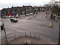
Nottingham - Bagthorpe area
The Perry Rd/Hucknall Rd junction viewed from the HMP Nottingham staff car park. The red van parked in Perry Rd and the area behind the parade of shops are part of the Berridge (local government) ward, whereas the area in the foreground sits within Sherwood ward.
Image: © David Hallam-Jones
Taken: 10 Mar 2012
0.07 miles
8

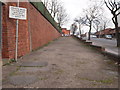
Perry Road, Sherwood
Completely deserted on a Sunday Morning. The appropriately grim concrete curtain wall on the left is part of Nottingham prison, and the low brick building on the right, now boarded up, used to house an engineering works.
Image: © Oxymoron
Taken: 17 Aug 2008
0.07 miles
10
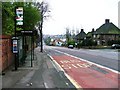
Bagthorpe NG5, Nottingham.
Hucknall Road (the A611) seen here from Compton Road. The bus is less than 100 yds away from Perry Road crossroads. H.M.Prison Nottingham, once known as Bagthorpe Gaol, is situated in Perry Road.
Image: © David Hallam-Jones
Taken: 13 Jun 2013
0.08 miles