IMAGES TAKEN NEAR TO
Hucknall Road, NOTTINGHAM, NG5 1FS
Introduction
This page details the photographs taken nearby to Hucknall Road, NG5 1FS by members of the Geograph project.
The Geograph project started in 2005 with the aim of publishing, organising and preserving representative images for every square kilometre of Great Britain, Ireland and the Isle of Man.

There are currently over 7.5m images from over14,400 individuals and you can help contribute to the project by visiting https://www.geograph.org.uk
Image Map
Images are licensed for reuse under creativecommons.org/licenses/by-sa/2.0
Notes
- Clicking on the map will re-center to the selected point.
- The higher the marker number, the further away the image location is from the centre of the postcode.
Image Listing (75 Images Found)
Images are licensed for reuse under creativecommons.org/licenses/by-sa/2.0
Image
Details
Distance
1
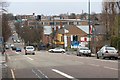
Hucknall Road
Looking towards the city
Image: © Mick Garratt
Taken: 29 Mar 2008
0.02 miles
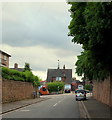
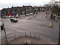
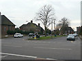
2
Nottingham - Bagthorpe neighbourhood
Glendon Road NG5. In the past this (much wider) neighbourhood was known as Bagthorpe. The race track layout of this road forms the entrance and exit to two branch roads at its far end.
Image: © David Hallam-Jones
Taken: 10 Mar 2012
0.04 miles
4

Shops at Perry Road
Typical 1930s tudorbethan style, matching the housing.
Image: © Alan Murray-Rust
Taken: 15 Mar 2009
0.04 miles
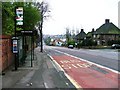
5
Bagthorpe NG5, Nottingham.
Hucknall Road (the A611) seen here from Compton Road. The bus is less than 100 yds away from Perry Road crossroads. H.M.Prison Nottingham, once known as Bagthorpe Gaol, is situated in Perry Road.
Image: © David Hallam-Jones
Taken: 13 Jun 2013
0.05 miles
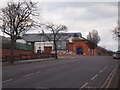
6
Nottingham - Bagthorpe area
The Perry Rd/Hucknall Rd junction viewed from the HMP Nottingham staff car park. The red van parked in Perry Rd and the area behind the parade of shops are part of the Berridge (local government) ward, whereas the area in the foreground sits within Sherwood ward.
Image: © David Hallam-Jones
Taken: 10 Mar 2012
0.05 miles
7
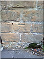
Benchmark on wall of Hucknall Road
Ordnance Survey cut mark benchmark described on the Bench Mark Database at http://www.bench-marks.org.uk/bm42701
Image: © Roger Templeman
Taken: 24 Apr 2012
0.05 miles
8
Nottingham - Bagthorpe
An unusable ancillary road forming a physical boundary between HMP Nottingham and Perry Road (Sherwood direction). The prison was known as Bagthorpe Gaol in the past.
Image: © David Hallam-Jones
Taken: 10 Mar 2012
0.06 miles
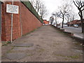
9
Nottingham - Bagthorpe
A view along Perry Rd in the direction of Sherwood with HMP Nottingham on left-hand side. His Majesty's Prison was opened in 1891 for the reception of 206 males and 31 females.
Image: © David Hallam-Jones
Taken: 10 Mar 2012
0.06 miles
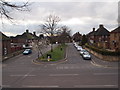
10
Remarkable road layout
Not obvious at first glance, but in fact these are two separately named roads on either side of the median strip - this side is Henley Rise, the further is Glendon Drive. The median strip appears to act as an elongated roundabout, judging by the bollard and the road markings, but there is no No Entry sign on Henley Rise. One wonders what the detailed traffic regulation orders are! At the end, the two roads go their separate ways as normal roads before joining again, at which point only Glendon Drive continues.
Image: © Alan Murray-Rust
Taken: 15 Mar 2009
0.08 miles