IMAGES TAKEN NEAR TO
Hereford Road, NOTTINGHAM, NG4 4WF
Introduction
This page details the photographs taken nearby to Hereford Road, NG4 4WF by members of the Geograph project.
The Geograph project started in 2005 with the aim of publishing, organising and preserving representative images for every square kilometre of Great Britain, Ireland and the Isle of Man.

There are currently over 7.5m images from over14,400 individuals and you can help contribute to the project by visiting https://www.geograph.org.uk
Image Map (Loading...)


Getting Data...Please wait
Leaflet Map data © OpenStreetMap
Images are licensed for reuse under creativecommons.org/licenses/by-sa/2.0
Notes
- Clicking on the map will re-center to the selected point.
- The higher the marker number, the further away the image location is from the centre of the postcode.
Image Listing (68 Images Found)
Images are licensed for reuse under creativecommons.org/licenses/by-sa/2.0
Image
Details
Distance
1
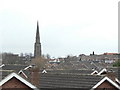
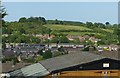
Across the rooftops
The delicate 13th century spire of Gedling church seen from Lambley Lane Recreation Ground.
Image: © Alan Murray-Rust
Taken: 1 Feb 2009
0.03 miles
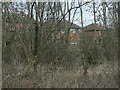
2
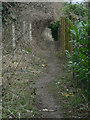
Footpath along the railway
This path leads out of the corner of Lambley Lane Recreation ground towards Gedling village, but there is no evidence of right of way across the recreation ground itself.
Image: © Alan Murray-Rust
Taken: 1 Feb 2009
0.06 miles
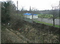
3
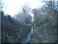
Railway trackbed, Gedling (1)
Maps generally still seem to mark this as a railway line, though here, where there was a foot crossing between Jessops Lane and a footpath, the track appears to have been lifted. This was the Great Northern Railway's "back line", which turned through 180 degrees around the edge of greater Nottingham to head eventually west into Derbyshire. After closure as a through route in the early 1960s, this section survived to provide rail access to Gedling Colliery, which closed in 1991.
Image: © Richard Vince
Taken: 11 Feb 2014
0.07 miles
4
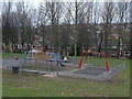
Play area
In Lambley Lane Recreation Ground (South)
Image: © Alan Murray-Rust
Taken: 1 Feb 2009
0.08 miles
5
View from Phoenix Avenue
Looking across the valley of the Ouse Beck to Gedling Wood. The hill doesn't appear to have a name of its own.
Image: © Alan Murray-Rust
Taken: 30 May 2020
0.09 miles
6
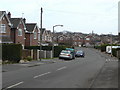
Lorimer Avenue
Housing development from the late 1970s to the east of Arnold Lane.
Image: © Alan Murray-Rust
Taken: 1 Feb 2009
0.09 miles
7
Houses on Jessops Lane
Seen from the footpath alongside the former railway line.
Image: © Alan Murray-Rust
Taken: 1 Feb 2009
0.10 miles
8
Railway cutting
From Lambley Lane bridge, looking over Lambley Lane Recreation Ground (South) towards Gedling church.
Image: © Alan Murray-Rust
Taken: 1 Feb 2009
0.10 miles
9
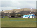
Lambley Lane Recreation Ground (South)
This section, to the south of Lambley Lane, comprises an all-weather cricket pitch and a children's play area. Behind can be seen the bridge carrying Lambley Lane over the former railway with the former Gedling Colliery spoil heap forming the backdrop.
Image: © Alan Murray-Rust
Taken: 1 Feb 2009
0.10 miles
10
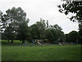
Children's play area Lambley Lane Recreation Ground
Image: © Jonathan Thacker
Taken: 5 Jun 2018
0.10 miles