IMAGES TAKEN NEAR TO
Church Street, NOTTINGHAM, NG4 4QB
Introduction
This page details the photographs taken nearby to Church Street, NG4 4QB by members of the Geograph project.
The Geograph project started in 2005 with the aim of publishing, organising and preserving representative images for every square kilometre of Great Britain, Ireland and the Isle of Man.

There are currently over 7.5m images from over14,400 individuals and you can help contribute to the project by visiting https://www.geograph.org.uk
Image Map
Images are licensed for reuse under creativecommons.org/licenses/by-sa/2.0
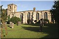
Notes
- Clicking on the map will re-center to the selected point.
- The higher the marker number, the further away the image location is from the centre of the postcode.
Image Listing (107 Images Found)
Images are licensed for reuse under creativecommons.org/licenses/by-sa/2.0
Image
Details
Distance
1
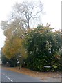
A little Autumn colour on a misty morning
Image: © Graham Hogg
Taken: 25 Oct 2016
0.01 miles
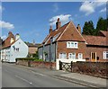
2
Cottages, Church Street, Lambley
Seventeenth century origins https://historicengland.org.uk/listing/the-list/list-entry/1227497
Image: © Jonathan Thacker
Taken: 10 Apr 2021
0.01 miles
3
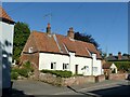
16 Church Street, Lambley
Dating back in part to the early 17th century, one of the small number of buildings of this era in Lambley. Listed Grade II.
Image: © Alan Murray-Rust
Taken: 30 May 2021
0.01 miles
4
16 Church Street, Lambley
Dating back in part to the early 17th century, one of the small number of building of this era in Lambley. Listed Grade II.
Image: © Alan Murray-Rust
Taken: 20 May 2020
0.02 miles
5
Lambley NG4, Notts.
A second extension (the furthest away) appears to have been added to the south side of the church. Church Lane and the "Top Dumble" (a.k.a "Upper Dumble") exist - at a lower level than the church - to the photographer's right (albeit not visible). The dumbles are said to be the most picturesque natural feature of the village. These are a series of small deep valleys - carrying Cocker Beck ("Crooked stream") - through into the village from the Mapperley Plains direction, i.e. the west.
Image: © David Hallam-Jones
Taken: 12 May 2013
0.02 miles
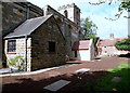
6
Pump, Church Street, Lambley
I photographed this some years back when the paint was new http://www.villagepumps.org.uk/pumpsNotts.htm#L0B , although that version never got put on Geograph. The paint has weathered in the meantime!
Image: © Alan Murray-Rust
Taken: 20 May 2020
0.03 miles
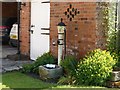
7

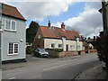
Church Street
The character of the village is maintained by it being a formal Conservation area http://www.gedling.gov.uk/lambley_ca_appraisal_final_-_august_07(adopted_sept_07).pdf
Image: © Alan Murray-Rust
Taken: 17 Oct 2008
0.03 miles
8
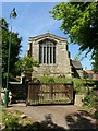
Church of the Holy Trinity, Lambley
The east end, with its fine late 15th century Perpendicular east window. Listed Grade I.
Image: © Alan Murray-Rust
Taken: 20 May 2020
0.03 miles
9
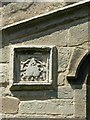
Church of the Holy Trinity, Lambley
Carved badge on the east end. This looks like some sort of insect, but in fact represents a money bag, the badge of Ralph Cromwell, the sponsor of the rebuilding of the church c.1470, See http://www.geograph.org.uk/photo/6482052 for location.
Image: © Alan Murray-Rust
Taken: 20 May 2020
0.03 miles