IMAGES TAKEN NEAR TO
Spring Lane, NOTTINGHAM, NG4 4PD
Introduction
This page details the photographs taken nearby to Spring Lane, NG4 4PD by members of the Geograph project.
The Geograph project started in 2005 with the aim of publishing, organising and preserving representative images for every square kilometre of Great Britain, Ireland and the Isle of Man.

There are currently over 7.5m images from over14,400 individuals and you can help contribute to the project by visiting https://www.geograph.org.uk
Image Map
Images are licensed for reuse under creativecommons.org/licenses/by-sa/2.0
Notes
- Clicking on the map will re-center to the selected point.
- The higher the marker number, the further away the image location is from the centre of the postcode.
Image Listing (48 Images Found)
Images are licensed for reuse under creativecommons.org/licenses/by-sa/2.0
Image
Details
Distance
1
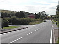
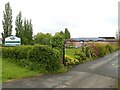
Junction of Spring Lane and Lambley Lane
Image: © Tom Courtney
Taken: 9 Aug 2005
0.07 miles
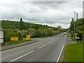
2
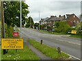
Lambley Lane closed until Summer 2021
As part of the construction of the Gedling Access Road. There had been partial closures previously, but this total closure has run for several months.
Image: © Alan Murray-Rust
Taken: 26 May 2021
0.07 miles
3
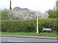
Fingerpost at Spring Lane/Lambley Lane
Notts C C traditional cast-iron with plain finial.
Image: © Alan Murray-Rust
Taken: 6 Apr 2014
0.07 miles
4
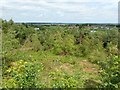
Gedling Country Park, northern viewpoint
Considerable tree clearance has been necessary to open out the distant view.
Image: © Alan Murray-Rust
Taken: 16 Jul 2020
0.08 miles
5
Nottingham Care Village
Residential, Dementia and Respite Care, developed in the late 20th century and much expanded around 2015.
Image: © Alan Murray-Rust
Taken: 26 May 2021
0.08 miles
6
Junction of Spring Lane and Lambley Lane
Recreating this 'First' for the square http://www.geograph.org.uk/photo/35725
Image: © Alan Murray-Rust
Taken: 26 May 2021
0.08 miles
7
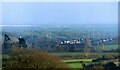
View from the Northern Viewpoint, Gedling Country Park
Catching the sunlight in the centre of the view is the tower and spire of St Mary Magdalen Church, Newark https://www.geograph.org.uk/snippet/6058 in square Image Not easy to pick out at the best of times (the picture has been tweaked to make it a bit more obvious) it is nevertheless one of the landmarks featured on the information boards at the viewpoint.
Image: © Alan Murray-Rust
Taken: 14 Dec 2020
0.08 miles
8
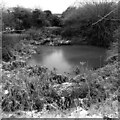
Frost in Gedling Country Park ? 9
Pond in the north east corner, near Lambley Lane.
Image: © Alan Murray-Rust
Taken: 24 Jan 2021
0.09 miles
9
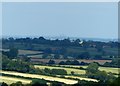
Gedling Country Park ? Can You See?
View from the northern viewpoint at the Park. The information board http://www.geograph.org.uk/photo/6543430 suggests that Lincoln Cathedral in Image is visible from here.
At full zoom of the camera it is just possible to make out the Cathedral, which is 45 km distant. Interestingly when it was caught by the sun it virtually disappeared against the sky. The Westgate Water Tower is much less visible, just discernible a little way to the left of the cathedral, immediately above the rounded dark tree.
Image: © Alan Murray-Rust
Taken: 16 Jul 2020
0.10 miles
10
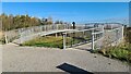
North-East viewing platform, Gedling Country Park
Image: © Chris Morgan
Taken: 8 Nov 2021
0.10 miles