IMAGES TAKEN NEAR TO
Glebe Farm View, NOTTINGHAM, NG4 4NZ
Introduction
This page details the photographs taken nearby to Glebe Farm View, NG4 4NZ by members of the Geograph project.
The Geograph project started in 2005 with the aim of publishing, organising and preserving representative images for every square kilometre of Great Britain, Ireland and the Isle of Man.

There are currently over 7.5m images from over14,400 individuals and you can help contribute to the project by visiting https://www.geograph.org.uk
Image Map
Images are licensed for reuse under creativecommons.org/licenses/by-sa/2.0
Notes
- Clicking on the map will re-center to the selected point.
- The higher the marker number, the further away the image location is from the centre of the postcode.
Image Listing (87 Images Found)
Images are licensed for reuse under creativecommons.org/licenses/by-sa/2.0
Image
Details
Distance
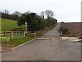
1
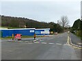
Gedling Access Road construction ? 251221 ? 10
Lambley Lane at the lower junction, now a cul-de-sac serving a small number of houses.
Image: © Alan Murray-Rust
Taken: 25 Dec 2021
0.06 miles
2
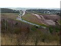
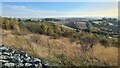
Gedling Access Road construction ? 251221 ? 16
The section between the two links with Lambley Lane looking towards Mapperley. New tree/shrub planting on the top of the cutting.
Image: © Alan Murray-Rust
Taken: 25 Dec 2021
0.08 miles
3
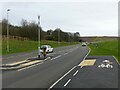
Gedling Access Road construction ? 251221 ? 7
The section between the two links with Lambley Lane is now open to traffic. The road at various stages of construction from the same viewpoint can be seen here https://www.geograph.org.uk/search.php?i=149328936&page=1&displayclass=slide
Image: © Alan Murray-Rust
Taken: 25 Dec 2021
0.08 miles
4
Gedling Access Road construction site ? 3
Looking west along the line of the road from Lambley Lane. This will be part of the new junction with Lambley Lane, which will involve two staggered T-junctions.
Image: © Alan Murray-Rust
Taken: 25 May 2020
0.08 miles
6
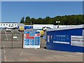
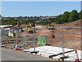
Gedling Access Road construction site ? 2
Entrance to the site and offices.
Note the Covid-19 social distancing sign on the right.
Image: © Alan Murray-Rust
Taken: 25 May 2020
0.09 miles
7
Gedling Access Road construction ? 251221 ? 13
The section between the two links with Lambley Lane is now open to traffic. The road is provided with a wide cycle and pedestrian way over its complete length which will provide a new pedestrian link as well as keeping cyclists separate from motor vehicles.
Image: © Alan Murray-Rust
Taken: 25 Dec 2021
0.09 miles
8
Gedling Access Road construction site ? 4
Looking east along the line of the road from Lambley Lane. This will be part of the new junction with Lambley Lane, which will involve two staggered T-junctions.
Image: © Alan Murray-Rust
Taken: 25 May 2020
0.10 miles
9
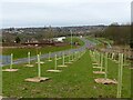
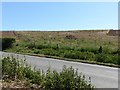
Gedling Access Road construction ? 251221 ? 15
The old alignment of Lambley Lane, now simply providing agricultural access.
Image: © Alan Murray-Rust
Taken: 25 Dec 2021
0.10 miles
10
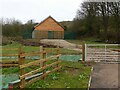
On the site of Glebe Farm
I was puzzled by this new building alongside the new Gedling Access Road, which didn't have any immediately obvious function. It clearly isn't a substation or pumphouse - there would be warning signs and ownership notices, and the doorway is too small. Further research after getting back home produced the information that it has been built to house the colony of bats which used to inhabit the old buildings of Glebe Farm which were demolished to make way for the new Gedling Access Road. When the image is viewed at its largest size, it is just possible to make out a number of entry holes - little paired rectangles - in the weatherboarding. The use of weatherboarding to blend the building in with the country park behind is rather negated by the substantial steel fence!
Image: © Alan Murray-Rust
Taken: 25 Dec 2021
0.10 miles