IMAGES TAKEN NEAR TO
Ashmore Close, NOTTINGHAM, NG4 4LT
Introduction
This page details the photographs taken nearby to Ashmore Close, NG4 4LT by members of the Geograph project.
The Geograph project started in 2005 with the aim of publishing, organising and preserving representative images for every square kilometre of Great Britain, Ireland and the Isle of Man.

There are currently over 7.5m images from over14,400 individuals and you can help contribute to the project by visiting https://www.geograph.org.uk
Image Map
Images are licensed for reuse under creativecommons.org/licenses/by-sa/2.0
Notes
- Clicking on the map will re-center to the selected point.
- The higher the marker number, the further away the image location is from the centre of the postcode.
Image Listing (51 Images Found)
Images are licensed for reuse under creativecommons.org/licenses/by-sa/2.0
Image
Details
Distance
1
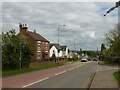
Scotgrave Farm on Arnold Lane, Gedling
Recreating this 'First' for the square http://www.geograph.org.uk/photo/35580. The old farmhouse is now surrounded by the new Chase Farm development.
Image: © Alan Murray-Rust
Taken: 25 May 2021
0.05 miles
2
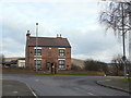
Scot Grave Farm
On Arnold Lane, backing onto the old Gedling Colliery site.
Image: © Alan Murray-Rust
Taken: 1 Feb 2009
0.05 miles
3
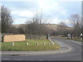
Scotgrave Farm on Arnold Lane, Gedling
Opposite the farm is the junction of Shelford Rd.
Image: © Tom Courtney
Taken: 9 Aug 2005
0.05 miles
4
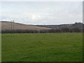
Field alongside Arnold Lane
The prominent hill to the left is the spoil heap of the former Gedling Colliery which lay behind the hedge to the right hand side of the picture.
Image: © Alan Murray-Rust
Taken: 1 Feb 2009
0.07 miles
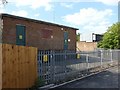
5
Substation at Gedling Colliery
This is now the only building remaining on the former colliery site, and only because it is still feeding to other places.
Image: © Alan Murray-Rust
Taken: 1 Feb 2009
0.08 miles
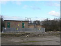
7
Substation on Waldrom Road, Gedling
A major local distribution point, the site doubtless chosen to be close to Gedling Colliery which would have been its major user. Now becoming surrounded by modern housing development.
Image: © Alan Murray-Rust
Taken: 30 May 2020
0.08 miles
8
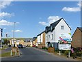
Chase Farm housing development
Gradually filling up the site of Gedling Colliery.
Image: © Alan Murray-Rust
Taken: 30 May 2020
0.09 miles
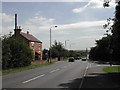
9
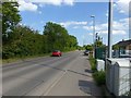
Arnold Lane, Gedling
Currently the A 6211, a major suburban through route, shortly to be superseded by the new Gedling Access Road.
Image: © Alan Murray-Rust
Taken: 30 May 2020
0.09 miles
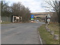
10
Entrance to Gedling Colliery
The blank brick wall until recently carried lettering to indicate that this was the site of Gedling Colliery, with its dates of opening and closing, and I was shocked to find that these have been removed. The road now leads to the local waste recycling centre.
Image: © Alan Murray-Rust
Taken: 1 Feb 2009
0.10 miles