IMAGES TAKEN NEAR TO
Avon Road, NOTTINGHAM, NG4 4JU
Introduction
This page details the photographs taken nearby to Avon Road, NG4 4JU by members of the Geograph project.
The Geograph project started in 2005 with the aim of publishing, organising and preserving representative images for every square kilometre of Great Britain, Ireland and the Isle of Man.

There are currently over 7.5m images from over14,400 individuals and you can help contribute to the project by visiting https://www.geograph.org.uk
Image Map (127 Images)
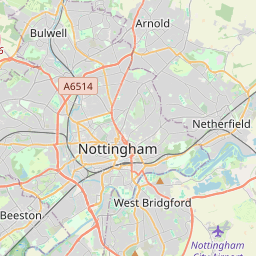

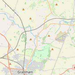

Leaflet Map data © OpenStreetMap
Images are licensed for reuse under creativecommons.org/licenses/by-sa/2.0
Notes
- Clicking on the map will re-center to the selected point.
- The higher the marker number, the further away the image location is from the centre of the postcode.
Image Listing (127 Images Found)
Images are licensed for reuse under creativecommons.org/licenses/by-sa/2.0
Image
Details
Distance
1
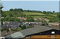
View from Phoenix Avenue
Looking across the valley of the Ouse Beck to Gedling Wood. The hill doesn't appear to have a name of its own.
Image: © Alan Murray-Rust
Taken: 30 May 2020
0.01 miles
2
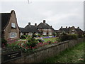
The Mary Hardstaff Homes
Date from 1934 https://historicengland.org.uk/listing/the-list/list-entry/1268312
Image: © Jonathan Thacker
Taken: 5 Jun 2018
0.04 miles
3
Manor Farmhouse, Arnold Lane, Gedling
Mid 18th century farmhouse of distinctive design with its three storey central section, almost a tower. This view shows the bowed north face. Listed Grade II.
Image: © Alan Murray-Rust
Taken: 1 Jan 2020
0.05 miles
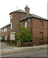
4
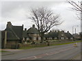
The Hardstaff Homes
Almshouses on Arnold Lane, close to Gedling church. Built in 1936 for the widows and orphans of miners, they were designed by Mr T Cecil Howitt, who had previously been the architect for Nottingham Council House. They are Grade II listed.
Image: © Alan Murray-Rust
Taken: 1 Feb 2009
0.06 miles
5
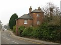
Manor Farmhouse, Arnold Lane, Gedling
Mid 18th century farmhouse of distinctive design with its three storey central section, almost a tower. Listed Grade II.
Image: © Alan Murray-Rust
Taken: 1 Jan 2020
0.06 miles
7
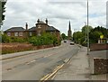
Gedling Church
Recreating this 'First' for the square https://www.geograph.org.uk/photo/35702 . The striking presence of the distant church is recognised in the title although it is only a small part of the picture. Manor Farmhouse, Listed Grade II, is more visible as the result of removal of trees.
Image: © Alan Murray-Rust
Taken: 25 May 2021
0.07 miles
8
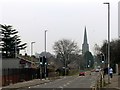
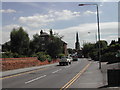
A Grade A start to 2020
Simply a grey day of course, but Grade A makes it feel better!
Arnold Lane Gedling at midday (more or less precisely - I had to wait for a van to clear the picture) on New Year's Day 2020. The elegant late 13th century tower and spire of All Hallows Church is a prominent landmark, rising to 180 feet, the second tallest in the county.
Image: © Alan Murray-Rust
Taken: 1 Jan 2020
0.07 miles
9
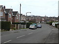
Lorimer Avenue
Housing development from the late 1970s to the east of Arnold Lane.
Image: © Alan Murray-Rust
Taken: 1 Feb 2009
0.10 miles
10
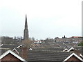
Across the rooftops
The delicate 13th century spire of Gedling church seen from Lambley Lane Recreation Ground.
Image: © Alan Murray-Rust
Taken: 1 Feb 2009
0.10 miles