IMAGES TAKEN NEAR TO
Charles Close, NOTTINGHAM, NG4 4EH
Introduction
This page details the photographs taken nearby to Charles Close, NG4 4EH by members of the Geograph project.
The Geograph project started in 2005 with the aim of publishing, organising and preserving representative images for every square kilometre of Great Britain, Ireland and the Isle of Man.

There are currently over 7.5m images from over14,400 individuals and you can help contribute to the project by visiting https://www.geograph.org.uk
Image Map
Images are licensed for reuse under creativecommons.org/licenses/by-sa/2.0
Notes
- Clicking on the map will re-center to the selected point.
- The higher the marker number, the further away the image location is from the centre of the postcode.
Image Listing (121 Images Found)
Images are licensed for reuse under creativecommons.org/licenses/by-sa/2.0
Image
Details
Distance
1
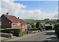
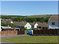
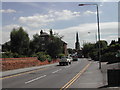
Gedling: Queen's Avenue and a view across the valley
The houses date from the early 1950s. Left of centre on the skyline is the spoil heap of Gedling Colliery, now green.
Image: © John Sutton
Taken: 3 Jun 2015
0.04 miles
2
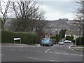
Queen's Avenue
Part of the large post-war development off Arnold Lane which was essentially a pit village for the neighbouring Gedling Colliery, although it abutted existing residential areas. The very broken terrain with relatively steep sided valleys and intervening ridges can be seen in this view. Although not obvious in this picture, the road name plate does not include an apostrophe, although the original road name does Image
Image: © Alan Murray-Rust
Taken: 1 Feb 2009
0.05 miles
3
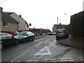
Lymn Avenue
Cul-de-sac off Queen's Avenue. Part of the large post-war development off Arnold Lane which was essentially a pit village for the neighbouring Gedling Colliery, although it abutted existing residential areas.
Image: © Alan Murray-Rust
Taken: 1 Feb 2009
0.05 miles
4
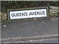
Queen's Avenue
One of the unusual road signs which appear to be very local to this estate. Most seem to have been replaced by more traditional plates on a metal frame. The road is on quite a steep gradient at this point, and the sign follows the gradient rather than being placed level. The more modern signs have dispensed with the apostrophe
Image: © Alan Murray-Rust
Taken: 1 Feb 2009
0.07 miles
5
View towards Gedling Country Park
The skyline is almost entirely man made, being the landscaped spoil tips of Gedling Colliery which would have been a prominent feature from this viewpoint. The housing was developed for colliery employees.
Image: © Alan Murray-Rust
Taken: 25 May 2020
0.07 miles
6
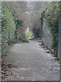
Apple Tree Lane
The name is a good indicator this is a footpath of some antiquity. Historical maps confirm that it existed before any housing was developed, and parts of it still exists further into the development Image
Image: © Alan Murray-Rust
Taken: 1 Feb 2009
0.08 miles
7
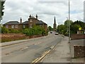
Gedling Church
Recreating this 'First' for the square https://www.geograph.org.uk/photo/35702 . The striking presence of the distant church is recognised in the title although it is only a small part of the picture. Manor Farmhouse, Listed Grade II, is more visible as the result of removal of trees.
Image: © Alan Murray-Rust
Taken: 25 May 2021
0.08 miles
8
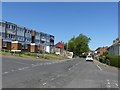
Phoenix Avenue, Gedling
Much of the area was housing for the neighbouring Gedling Colliery, with many roads named after other Nottinghamshire collieries.
Image: © Alan Murray-Rust
Taken: 25 May 2020
0.08 miles
10
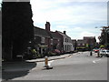
Main Road Gedling
The cottages on the left are some of the oldest in the village
Image: © Tom Courtney
Taken: 9 Aug 2005
0.09 miles