IMAGES TAKEN NEAR TO
Winster Avenue, NOTTINGHAM, NG4 3RW
Introduction
This page details the photographs taken nearby to Winster Avenue, NG4 3RW by members of the Geograph project.
The Geograph project started in 2005 with the aim of publishing, organising and preserving representative images for every square kilometre of Great Britain, Ireland and the Isle of Man.

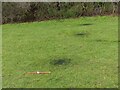
There are currently over 7.5m images from over14,400 individuals and you can help contribute to the project by visiting https://www.geograph.org.uk
Image Map
Images are licensed for reuse under creativecommons.org/licenses/by-sa/2.0
Notes
- Clicking on the map will re-center to the selected point.
- The higher the marker number, the further away the image location is from the centre of the postcode.
Image Listing (87 Images Found)
Images are licensed for reuse under creativecommons.org/licenses/by-sa/2.0
Image
Details
Distance
1
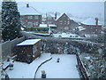
Buxton Avenue Snow
From Buxton Avenue looking towards Cromford Avenue and Cavendish Road Rec
Image: © Martin Jones
Taken: 23 Feb 2005
0.02 miles
2
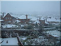
Carlton Snow
From Buxton Avenue looking past Cromford Avenue towards Carlton Cemetery
Image: © Martin Jones
Taken: 23 Feb 2005
0.04 miles
3
Recreation area off Cavendish Road
I have been able from my house to watch the woodland inside the fence growing from first planting. When the fence was first erected it was not clear what it was for. It seems to have served its purpose in ensuring that the growth has been pretty free of malicious damage. Now the function of the fence is presumably to maintain a reasonable wildlife habitat by deterring people from walking inside the area.
Image: © Alan Murray-Rust
Taken: 8 May 2008
0.10 miles
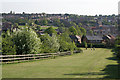
4
Belper Avenue
Looking south across Carlton Valley.
Image: © Alan Murray-Rust
Taken: 1 Feb 2009
0.10 miles
5
In with a bang - New Year 2021
The aftermath of fireworks to celebrate what everyone hopes will be a better year than 2020.
Image: © Alan Murray-Rust
Taken: 1 Jan 2021
0.11 miles
6
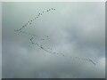
Grey geese against a grey sky
Flying over Carlton Cemetery.
Image: © Alan Murray-Rust
Taken: 1 Jan 2021
0.11 miles
7
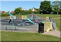
Recreation ground off Cavendish Road
Children's play area, closed due to Covid-19
Image: © Alan Murray-Rust
Taken: 25 May 2020
0.11 miles
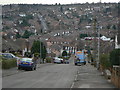
8
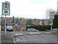
The crest of Belper Avenue
Looking north north east towards Westdale Lane. The wording on the road states FIRE PATH, but the main reason for the exception for heavy vehicles for load is almost certainly to allow the passage of bin lorries.
Image: © Alan Murray-Rust
Taken: 1 Feb 2009
0.12 miles
9

White on blue
Freshly broken-out cherry blooms against a pure blue sky.
Image: © Alan Murray-Rust
Taken: 5 Apr 2020
0.12 miles
10
The crest of Belper Avenue
Behind the photographer, Belper Avenue becomes Baslow Avenue. The blocks in the road are to prevent the use of the roads as a short cut between Cavendish Road and Westdale Lane. The relaxation of the restriction for vehicles over 35 cwt for loading is almost certainly specifically to allow passage for bin lorries, as there is no means of turning at the barrier. See also Image
Image: © Alan Murray-Rust
Taken: 1 Feb 2009
0.12 miles