IMAGES TAKEN NEAR TO
Lavender Crescent, NOTTINGHAM, NG4 3QY
Introduction
This page details the photographs taken nearby to Lavender Crescent, NG4 3QY by members of the Geograph project.
The Geograph project started in 2005 with the aim of publishing, organising and preserving representative images for every square kilometre of Great Britain, Ireland and the Isle of Man.

There are currently over 7.5m images from over14,400 individuals and you can help contribute to the project by visiting https://www.geograph.org.uk
Image Map
Images are licensed for reuse under creativecommons.org/licenses/by-sa/2.0
Notes
- Clicking on the map will re-center to the selected point.
- The higher the marker number, the further away the image location is from the centre of the postcode.
Image Listing (14 Images Found)
Images are licensed for reuse under creativecommons.org/licenses/by-sa/2.0
Image
Details
Distance
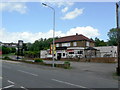
1
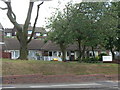
Cavendish Road Community Centre
Now run by Gedling Homes, the housing trust set up to run the former Gedling Borough Council housing stock. It is part of a development of around 20 bungalow-style properties for the elderly along Cavendish Road.
Image: © Alan Murray-Rust
Taken: 24 May 2011
0.10 miles
2
Elderly persons' bungalows, Cavendish Road
Originally Gedling Borough Council housing property, now run by Gedling Homes housing trust.
Image: © Alan Murray-Rust
Taken: 24 May 2011
0.13 miles
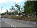
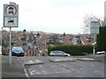
3
The crest of Belper Avenue
Behind the photographer, Belper Avenue becomes Baslow Avenue. The blocks in the road are to prevent the use of the roads as a short cut between Cavendish Road and Westdale Lane. The relaxation of the restriction for vehicles over 35 cwt for loading is almost certainly specifically to allow passage for bin lorries, as there is no means of turning at the barrier. See also Image
Image: © Alan Murray-Rust
Taken: 1 Feb 2009
0.16 miles
4
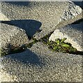
Light, shade and texture
Anti-drive-through paving blocks. See http://www.geograph.org.uk/photo/6728808 for location.
Image: © Alan Murray-Rust
Taken: 12 Jan 2021
0.16 miles
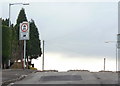
5
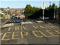
Fire path, keep clear
Anti-rat-run blocks on Belper Avenue which still allow for passage of large emergency vehicles.
Image: © Alan Murray-Rust
Taken: 12 Jan 2021
0.16 miles
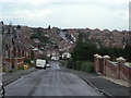
6
The crest of Belper Avenue
Looking north north east towards Westdale Lane. The wording on the road states FIRE PATH, but the main reason for the exception for heavy vehicles for load is almost certainly to allow the passage of bin lorries.
Image: © Alan Murray-Rust
Taken: 1 Feb 2009
0.17 miles
7
Baslow Avenue
Looking down to Westdale Lane. This road and its neighbours to the southeast are known locally as the 'Derbyshire Roads' because of their names.
Image: © Alan Murray-Rust
Taken: 1 Feb 2009
0.19 miles
8
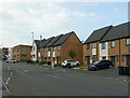
Housing on Cavendish Road
Developed around 2015 on the site of The Cavendish public house which had closed around 2010 https://www.geograph.org.uk/photo/2427869
Image: © Alan Murray-Rust
Taken: 27 May 2021
0.19 miles
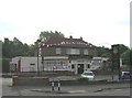
10
The Cavendish, Cavendish Road, Carlton
The Hand Car Wash sign conceals the 'To Let' sign on the front of this pub, which appears to be yet another suburban road-house-style-pub casualty.
Image: © Alan Murray-Rust
Taken: 24 May 2011
0.21 miles