IMAGES TAKEN NEAR TO
Appletree Lane, NOTTINGHAM, NG4 3LA
Introduction
This page details the photographs taken nearby to Appletree Lane, NG4 3LA by members of the Geograph project.
The Geograph project started in 2005 with the aim of publishing, organising and preserving representative images for every square kilometre of Great Britain, Ireland and the Isle of Man.

There are currently over 7.5m images from over14,400 individuals and you can help contribute to the project by visiting https://www.geograph.org.uk
Image Map (Loading...)


Getting Data...Please wait
Leaflet Map data © OpenStreetMap
Images are licensed for reuse under creativecommons.org/licenses/by-sa/2.0
Notes
- Clicking on the map will re-center to the selected point.
- The higher the marker number, the further away the image location is from the centre of the postcode.
Image Listing (117 Images Found)
Images are licensed for reuse under creativecommons.org/licenses/by-sa/2.0
Image
Details
Distance
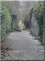
1
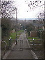
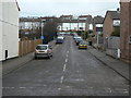
Apple Tree Lane
The lower part of this footpath. It now provides - unofficially - vehicle access to some of the adjoining premises, for which the foundations of the path are clearly not sufficiently strong.
Image: © Alan Murray-Rust
Taken: 1 Feb 2009
0.04 miles
2
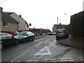
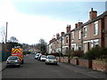
Lymn Avenue
Cul-de-sac off Queen's Avenue. Part of the large post-war development off Arnold Lane which was essentially a pit village for the neighbouring Gedling Colliery, although it abutted existing residential areas.
Image: © Alan Murray-Rust
Taken: 1 Feb 2009
0.05 miles
3
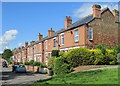
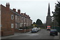
Gedling: Priory Road
Houses built in the first years of the twentieth century, seen from the corner of Apple Tree Lane on a sunny June morning.
Image: © John Sutton
Taken: 3 Jun 2015
0.06 miles
4
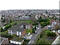
Friday Lane and Priory Road, Gedling
Seen from the tower of All Hallows Church – an unexpected bonus on a casual visit.
Image: © Alan Murray-Rust
Taken: 8 Jan 2020
0.06 miles
5
Priory Road
Looking north east with Gedling church in the background.
Image: © Alan Murray-Rust
Taken: 1 Feb 2009
0.06 miles
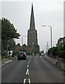
6
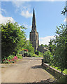
Gedling: Friday Lane and All Hallows' spire
Gedling's wonderful 180ft spire (1300-20) is the second tallest in the county. For more about it, see Image
Image: © John Sutton
Taken: 3 Jun 2015
0.07 miles
7
Third Avenue
Houses from the 60s/70s, although the road itself appears to day from the time the main street (Priory Road) that it branches off.
Image: © Alan Murray-Rust
Taken: 1 Feb 2009
0.07 miles
8
Priory Road
Development from just after the turn of the 20th Century. The next row of houses behind this set was not built until the 60s or 70s.
Image: © Alan Murray-Rust
Taken: 1 Feb 2009
0.08 miles
9
Apple Tree Lane
The name is a good indicator this is a footpath of some antiquity. Historical maps confirm that it existed before any housing was developed, and parts of it still exists further into the development Image
Image: © Alan Murray-Rust
Taken: 1 Feb 2009
0.09 miles
10
Gedling: All Hallows' spire
When our art teacher, Mrs Macmillan, expatiated on The Parthenon and its columns, she was able to recommend a cycle or bus ride across the city to see entasis in action in the spire of Gedling church. ("The sides of the spire," wrote Nikolaus Pevsner, "actually have a slight, ingenious entasis. The effect is elegant, almost sensuous, in an Indian way, as it were.") The 180ft steeple (1300-20), the second tallest in Nottinghamshire, is seen from a pedestrian refuge on Arnold Lane on a gloomy September morning.
For more about entasis, see http://en.wikipedia.org/wiki/Entasis .
Image: © John Sutton
Taken: 25 Sep 2013
0.09 miles