IMAGES TAKEN NEAR TO
Brooklands Crescent, NOTTINGHAM, NG4 3GW
Introduction
This page details the photographs taken nearby to Brooklands Crescent, NG4 3GW by members of the Geograph project.
The Geograph project started in 2005 with the aim of publishing, organising and preserving representative images for every square kilometre of Great Britain, Ireland and the Isle of Man.

There are currently over 7.5m images from over14,400 individuals and you can help contribute to the project by visiting https://www.geograph.org.uk
Image Map
Images are licensed for reuse under creativecommons.org/licenses/by-sa/2.0
Notes
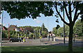
- Clicking on the map will re-center to the selected point.
- The higher the marker number, the further away the image location is from the centre of the postcode.
Image Listing (39 Images Found)
Images are licensed for reuse under creativecommons.org/licenses/by-sa/2.0
Image
Details
Distance
1
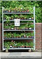
All on trolley ?1
I don't think that is quite what is intended – 'Anything on trolley £1' would be better.
Image: © Alan Murray-Rust
Taken: 4 Jul 2016
0.09 miles
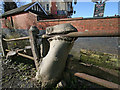
2
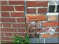
Bench mark, Ouse Bridge, Burton Road
Suffering from rather weathered brick. See http://www.geograph.org.uk/photo/5024115 for location.
Image: © Alan Murray-Rust
Taken: 4 Jul 2016
0.09 miles
3
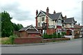
Inn for a Penny and Ouse Bridge
The pub was originally the Royal Oak, but has been the Inn for a Penny for as long as I can remember.
Ouse Bridge is a rather grand name for what is a culvert over a rather small stream, the Ouse Dyke. There is a bench mark http://www.geograph.org.uk/photo/5024112 at the right hand end of the parapet.
Image: © Alan Murray-Rust
Taken: 4 Jul 2016
0.10 miles
5
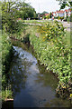
Ouse Dyke from Conway Road
The water is remarkably clear considering that this stream drains the landfill site on the former Gedling Colliery waste tip.
Image: © Alan Murray-Rust
Taken: 8 May 2008
0.11 miles
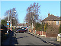
6
Burton Road Culvert
Next to Inn For A Penny
Image: © Martin Jones
Taken: 21 Mar 2008
0.12 miles
7
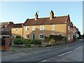
24 Shearing Hill, Gedling
Early 18th century farmhouse with later additions, Listed Grade II.
Image: © Alan Murray-Rust
Taken: 15 Jan 2020
0.12 miles
8
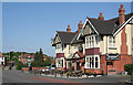
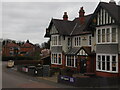
Inn for a Penny
A large roadhouse-style pub from the tween-wars period on Burton Road.
Image: © Alan Murray-Rust
Taken: 8 May 2008
0.12 miles
9
Gedling, Burton Road after Francis Frith
Taken to show how Francis Frith's view from c.1960 http://www.francisfrith.com/search/england/nottinghamshire/gedling/photos/gedling_G311014.htm looks today.
Trees have replaced the flower beds on the near corner, there are new trees along the recreation ground to the right (not the ones on Frith's view which are at the kerb edge and have been removed at some stage) and those along the railway embankment now dwarf the railway bridge. The road junction now sports a fine set of traffic lights. At the time of Frith's view, the Colwick Loop Road had not been built, so the main road (Burton Road) was then the one coming in from the left and continuing straight ahead.
Image: © Alan Murray-Rust
Taken: 19 Jun 2008
0.12 miles
10
Coronation Walk
The name indicates that this small estate was developed in the early 1950s.
Image: © Alan Murray-Rust
Taken: 18 Jan 2009
0.12 miles