IMAGES TAKEN NEAR TO
De Buseli Close, NOTTINGHAM, NG4 2SH
Introduction
This page details the photographs taken nearby to De Buseli Close, NG4 2SH by members of the Geograph project.
The Geograph project started in 2005 with the aim of publishing, organising and preserving representative images for every square kilometre of Great Britain, Ireland and the Isle of Man.

There are currently over 7.5m images from over14,400 individuals and you can help contribute to the project by visiting https://www.geograph.org.uk
Image Map
Images are licensed for reuse under creativecommons.org/licenses/by-sa/2.0
Notes
- Clicking on the map will re-center to the selected point.
- The higher the marker number, the further away the image location is from the centre of the postcode.
Image Listing (41 Images Found)
Images are licensed for reuse under creativecommons.org/licenses/by-sa/2.0
Image
Details
Distance
1
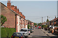
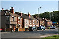
Florence Road
This terrace of houses was very much an outsider when built, being beyond the railway, but development caught up as can be seen by the variety of later housing styles.
Image: © Alan Murray-Rust
Taken: 8 May 2008
0.05 miles
2
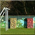
Forms and colour
In Jubilee Park recreation ground. Mural painting on the retaining wall alongside the former railway embankment, and a gantry for a zip-wire.
Image: © Alan Murray-Rust
Taken: 17 Dec 2020
0.05 miles
3
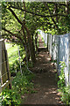
Footpath over the railway
This makes use of the bridge of the old Great Northern line (now derelict) from Colwick to Daybrook Junction and on to Derby to cross the old Midland Railway line from Nottingham to Newark.
Image: © Alan Murray-Rust
Taken: 8 May 2008
0.07 miles
4
Shade and shape ? 1
Skatepark in Jubilee Park recreation ground.
Image: © Alan Murray-Rust
Taken: 17 Dec 2020
0.07 miles
5
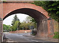
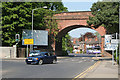
Carlton NG4, Notts.
The foot of Shearing Hill (the A6211) is seen joining Burton Road (the B686) in this view through this former railway bridge. Traffic that has descended Shearing Hill and that is waiting to join the B686 would be facing Burton Road Recreation Ground.
Image: © David Hallam-Jones
Taken: 12 May 2013
0.07 miles
6
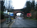
Railway bridge over Burton Road, Gedling
The bridge carries the disused remnant of the Great Northern Railway's "back line" around the eastern suburbs of Nottingham that survived into the 1990s to serve Gedling colliery (closed 1991).
Image: © Richard Vince
Taken: 29 Nov 2014
0.07 miles
7
Shade and shape ? 2
Skateboard park in Jubilee Park recreation ground.
Image: © Alan Murray-Rust
Taken: 17 Dec 2020
0.08 miles
8
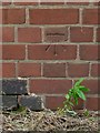
Bench mark, Burton Road railway bridge
See http://www.geograph.org.uk/photo/793901 for location.
Image: © Alan Murray-Rust
Taken: 4 Jul 2016
0.08 miles
9
The Holly and the Ivy
The nearer block of four houses is called Holly Villa, the pair beyond is Ivy Villa.
Image: © Alan Murray-Rust
Taken: 8 May 2008
0.09 miles
10
Burton Road railway bridge
This is the basic reason why a new bypass road has been built. There was always a significant traffic flow making the right turn like this car, which blocked traffic making for Nottingham City Centre due to the short approach lanes. The bridge carries a derelict railway which latterly served Gedling Colliery; there are proposals to use the alignment for a further route of the Nottingham tram as part of a major expansion of housing development.
There is a bench mark http://www.geograph.org.uk/photo/5024111 on the left hand abutment.
Image: © Alan Murray-Rust
Taken: 8 May 2008
0.09 miles