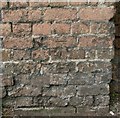
1
Stoke Lane allotments
Seen from the footpath which alongside the western edge.
Image: © Alan Murray-Rust
Taken: 24 May 2010
0.02 miles
2
Railway bridge, Emerys Road
Image: © JThomas
Taken: 15 Mar 2010
0.06 miles
3
Railway bridge, Chandos Street
As built, the bridge simply catered for a farm track, and was never enlarged when Chandos Street and later Emerys Road were created. It still has no footway, and from this side approaching traffic has no real view through.
There is a bench mark http://www.geograph.org.uk/photo/5024106 on the pier at the end of the left hand abutment.
Image: © Alan Murray-Rust
Taken: 4 Jul 2016
0.06 miles
4
Bench mark, railway bridge, Chandos Street
See http://www.geograph.org.uk/photo/5024104 for location.
Image: © Alan Murray-Rust
Taken: 4 Jul 2016
0.06 miles
5
Bus on Chandos Street, Netherfield – 1986
In the run-up to the deregulation of bus services in October 1986, City of Nottingham Transport introduced a series of ‘Accessline’ services using small buses to reach areas that could not be served by full size buses. The idea was that these areas would not be attractive to possible competitors after deregulation and that passengers would be attracted to use these localised services rather than walk to main roads. These services were never economically viable and in most cases services were withdrawn soon after deregulation and have not been replaced since.
Chandos Street is one of the few sections where a limited service has been maintained, although the route is substantially different from the Accessline service.
The railway bridge carried the line up to Gedling Colliery, at that time still operational. Originally it formed part of the Great Northern Railway’s very roundabout route from Nottingham to Derby, via Colwick, Basford, and Ilkeston.
Image: © Alan Murray-Rust
Taken: 1 May 1986
0.09 miles
6
Shade and shape ? 1
Skatepark in Jubilee Park recreation ground.
Image: © Alan Murray-Rust
Taken: 17 Dec 2020
0.15 miles
7
Shade and shape ? 2
Skateboard park in Jubilee Park recreation ground.
Image: © Alan Murray-Rust
Taken: 17 Dec 2020
0.15 miles
8
Footpath over the railway
This makes use of the bridge of the old Great Northern line (now derelict) from Colwick to Daybrook Junction and on to Derby to cross the old Midland Railway line from Nottingham to Newark.
Image: © Alan Murray-Rust
Taken: 8 May 2008
0.17 miles
9
Burton Road Recreation Ground
Football in winter, cricket in the summer
Image: © Alan Murray-Rust
Taken: 8 May 2008
0.17 miles
10
Bridge over the Ouse Dyke, Chandos Street
The road rises considerably to cross what is quite a small stream. There is a bench mark http://www.geograph.org.uk/photo/5024102on the parapet to the left.
Image: © Alan Murray-Rust
Taken: 4 Jul 2016
0.18 miles


