IMAGES TAKEN NEAR TO
Conway Road, NOTTINGHAM, NG4 2QB
Introduction
This page details the photographs taken nearby to Conway Road, NG4 2QB by members of the Geograph project.
The Geograph project started in 2005 with the aim of publishing, organising and preserving representative images for every square kilometre of Great Britain, Ireland and the Isle of Man.

There are currently over 7.5m images from over14,400 individuals and you can help contribute to the project by visiting https://www.geograph.org.uk
Image Map (Loading...)


Getting Data...Please wait
Leaflet Map data © OpenStreetMap
Images are licensed for reuse under creativecommons.org/licenses/by-sa/2.0
Notes
- Clicking on the map will re-center to the selected point.
- The higher the marker number, the further away the image location is from the centre of the postcode.
Image Listing (30 Images Found)
Images are licensed for reuse under creativecommons.org/licenses/by-sa/2.0
Image
Details
Distance
1
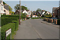
Conway Crescent
A quiet backwater of tween-wars housing on the garden suburb principle.
Image: © Alan Murray-Rust
Taken: 8 May 2008
0.06 miles
2
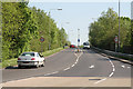
Colwick Loop Road
Hardly 25 years old, this bypass has itself been superseded by a new road a bit further east.
Image: © Alan Murray-Rust
Taken: 8 May 2008
0.10 miles
3
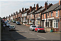
Willow Road
This road marks virtually the end of Victorian development; further east (right) the housing is very different in character, being tween wars housing development.
Image: © Alan Murray-Rust
Taken: 8 May 2008
0.11 miles
4
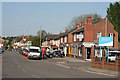
Shops on Burton Road
The mix is very much the standard modern set - chippy, computer repairs, hairdresser, closed Post Office, newsagent, takeaway and estate agent. However, the filling station does have a small supermarket attached.
Image: © Alan Murray-Rust
Taken: 8 May 2008
0.12 miles
5
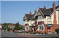
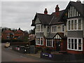
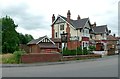
Inn for a Penny
A large roadhouse-style pub from the tween-wars period on Burton Road.
Image: © Alan Murray-Rust
Taken: 8 May 2008
0.13 miles
6
Burton Road Culvert
Next to Inn For A Penny
Image: © Martin Jones
Taken: 21 Mar 2008
0.13 miles
7
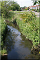
Ouse Dyke from Conway Road
The water is remarkably clear considering that this stream drains the landfill site on the former Gedling Colliery waste tip.
Image: © Alan Murray-Rust
Taken: 8 May 2008
0.14 miles
8
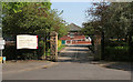
Conway Street Recreation Ground
The entrance on Conway Road
Image: © Alan Murray-Rust
Taken: 8 May 2008
0.14 miles
10
Inn for a Penny and Ouse Bridge
The pub was originally the Royal Oak, but has been the Inn for a Penny for as long as I can remember.
Ouse Bridge is a rather grand name for what is a culvert over a rather small stream, the Ouse Dyke. There is a bench mark http://www.geograph.org.uk/photo/5024112 at the right hand end of the parapet.
Image: © Alan Murray-Rust
Taken: 4 Jul 2016
0.15 miles