IMAGES TAKEN NEAR TO
Drummond Avenue, NOTTINGHAM, NG4 2PR
Introduction
This page details the photographs taken nearby to Drummond Avenue, NG4 2PR by members of the Geograph project.
The Geograph project started in 2005 with the aim of publishing, organising and preserving representative images for every square kilometre of Great Britain, Ireland and the Isle of Man.

There are currently over 7.5m images from over14,400 individuals and you can help contribute to the project by visiting https://www.geograph.org.uk
Image Map
Images are licensed for reuse under creativecommons.org/licenses/by-sa/2.0
Notes
- Clicking on the map will re-center to the selected point.
- The higher the marker number, the further away the image location is from the centre of the postcode.
Image Listing (31 Images Found)
Images are licensed for reuse under creativecommons.org/licenses/by-sa/2.0
Image
Details
Distance
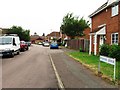
3
Housing on Cross Street, Gedling
The house at this end of the terrace appears to have been a corner shop in the past.
Image: © Richard Vince
Taken: 11 Feb 2014
0.13 miles
4
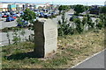
Commemorative stone
Recording the opening of the final stage of the Colwick bypass road.
Image: © Alan Murray-Rust
Taken: 24 May 2010
0.16 miles
5
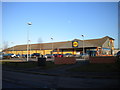
LiDL supermarket, Netherfield
Situated on the eastern edge of Netherfield. Access is from Great Northern Way (foreground), a small commemoration of the previous use of this site for a locomotive shed and marshalling yards built by the Great Northern Railway (see Image).
Image: © Richard Vince
Taken: 11 Feb 2014
0.16 miles
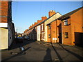
6
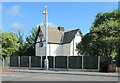
Netherfield: former Level Crossing Keeper's House
Built by the Great Northern Railway where its busy Derbyshire Extension (The Back Line) crossed Netherfield Lane (now Victoria Road). There was also a signal box here, to the left of the house, which lasted until the 1980s, when The Back Line existed only to serve Gedling Colliery.
Image: © John Sutton
Taken: 22 Aug 2013
0.16 miles
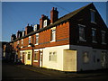
7
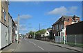
Netherfield: Victoria Road and the former railway institute
A view towards where the Great Northern Railway Derbyshire Extension (The Back Line) crossed - the white building on the right-hand side of the road was once the crossing-keeper's house. The red-brick building on the right was built as the railwaymen's institute. The huge Colwick engine shed and marshalling yards stretched north and east to the right (see Ben Brooksbank's Image] for a flavour of what was here). The site behind the grey security fence on the right was once occupied by Traffic Terrace, one of two rows of houses built by the railway company either side of the engine shed frontage.
Image: © John Sutton
Taken: 22 Aug 2013
0.16 miles
8
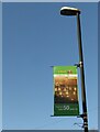
Colwick Loco 50 years on ? 3
One of a set of banners http://www.geograph.org.uk/photo/6709018 http://www.geograph.org.uk/photo/6709020 installed along Victoria Road commemorating Colwick locomotive shed which closed in 1970. The shed was one of the largest in the UK, with an allocation at its maximum of around 200 steam locomotives. It was attached to the extensive marshalling sidings where trains from collieries in the Nottinghamshire/Derbyshire area were formed into larger trains for onward movement to London in particular. The banners mark the passage from the original Great Northern Railway, through the London and North Eastern Railway and finally British Railways. See http://www.geograph.org.uk/photo/6709023 for location.
Image: © Alan Murray-Rust
Taken: 17 Dec 2020
0.16 miles
9
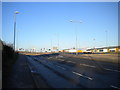
Colwick Loop Road, Netherfield
At this point, the new Loop Road continues straight on, while the old Loop Road bears left towards Gedling. The newer road was built to bypass the very narrow part of Burton Road that is constricted by a railway bridge crossing it just east of Shearing Hill.
Image: © Richard Vince
Taken: 11 Feb 2014
0.17 miles
10
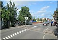
Netherfield: disused level crossing
Built by the Great Northern Railway where its busy Derbyshire Extension (The Back Line) crossed Netherfield Lane (now Victoria Road). There was also a signal box here (offstage right) which lasted until the 1980s, when The Back Line existed only to serve Gedling Colliery.
Image: © John Sutton
Taken: 22 Aug 2013
0.17 miles