IMAGES TAKEN NEAR TO
Victoria Park Way, NOTTINGHAM, NG4 2PA
Introduction
This page details the photographs taken nearby to Victoria Park Way, NG4 2PA by members of the Geograph project.
The Geograph project started in 2005 with the aim of publishing, organising and preserving representative images for every square kilometre of Great Britain, Ireland and the Isle of Man.

There are currently over 7.5m images from over14,400 individuals and you can help contribute to the project by visiting https://www.geograph.org.uk
Image Map
Images are licensed for reuse under creativecommons.org/licenses/by-sa/2.0
Notes
- Clicking on the map will re-center to the selected point.
- The higher the marker number, the further away the image location is from the centre of the postcode.
Image Listing (26 Images Found)
Images are licensed for reuse under creativecommons.org/licenses/by-sa/2.0
Image
Details
Distance
1
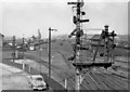
Colwick Yard Complex
View WNW from the footbridge over the line to the adjoining ex-LNW locomotive shed, to the western part of the vast ex-LNER Colwick Yards and towards Gedling etc. on the Nottingham Avoiding Line. The signalbox is Locomotive Junction, the great ex-GNR Locomotive Depot, with an allocation of over 200 engines is off to the left. It was a very difficult complex to access from public roads. My car is in the foreground. Fifty years ago, this was a very major railway centre, dealing with an immense freight traffic, especially coal, but all has long since gone in the modern age.
Image: © Ben Brooksbank
Taken: 27 Mar 1956
0.04 miles
3
No entry to trainspotters
50 years ago, when this area was part of Colwick marshalling yards, this notice would have made sense. Now, it's just a question of reading the notice correctly!
Image: © Alan Murray-Rust
Taken: 22 Dec 2020
0.08 miles
4

Willow flower
The male catkin has developed into the flowering stage with long stamens.
Image: © Alan Murray-Rust
Taken: 31 Mar 2021
0.12 miles
5

Crack Willow catkins
The seeds are nearing full ripeness but have not yet developed the feathery pappae which will allow them to be carried off in the wind.
Image: © Alan Murray-Rust
Taken: 31 Mar 2021
0.12 miles
6
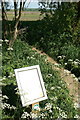
Permissive paths
The panel records the opening of 22 km of permissive paths and bridleways right across the Severn Trent Stoke Bardolph estate, in conjunction with English Nature. This is an exceptionally extensive network.
Image: © Alan Murray-Rust
Taken: 24 May 2010
0.12 miles
7
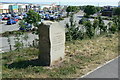
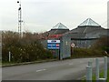
Commemorative stone
Recording the opening of the final stage of the Colwick bypass road.
Image: © Alan Murray-Rust
Taken: 24 May 2010
0.13 miles
8
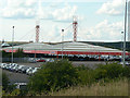
Colwick Loco 50 years on ? 5
For fuller information see http://www.geograph.org.uk/photo/6709023 . Colwick locomotive shed occupied the left hand half of the photograph with the extensive marshalling yards ahead and to the right of the view.
Image: © Alan Murray-Rust
Taken: 17 Dec 2020
0.13 miles
9
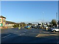
Colwick Loop Road, Netherfield
At this point, the new Loop Road continues straight on, while the old Loop Road bears left towards Gedling. The newer road was built to bypass the very narrow part of Burton Road that is constricted by a railway bridge crossing it just east of Shearing Hill.
Image: © Richard Vince
Taken: 11 Feb 2014
0.13 miles
10
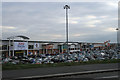
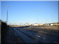
Car auction yard
In years past this site was covered by the Colwick railway yards, where the old Great Northern Railway concentrated its freight traffic - principally coal - for onward travel towards London.
Image: © Alan Murray-Rust
Taken: 5 Jul 2009
0.14 miles