IMAGES TAKEN NEAR TO
Caxton Close, NOTTINGHAM, NG4 2JL
Introduction
This page details the photographs taken nearby to Caxton Close, NG4 2JL by members of the Geograph project.
The Geograph project started in 2005 with the aim of publishing, organising and preserving representative images for every square kilometre of Great Britain, Ireland and the Isle of Man.

There are currently over 7.5m images from over14,400 individuals and you can help contribute to the project by visiting https://www.geograph.org.uk
Image Map
Images are licensed for reuse under creativecommons.org/licenses/by-sa/2.0
Notes
- Clicking on the map will re-center to the selected point.
- The higher the marker number, the further away the image location is from the centre of the postcode.
Image Listing (49 Images Found)
Images are licensed for reuse under creativecommons.org/licenses/by-sa/2.0
Image
Details
Distance
1
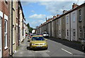
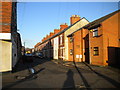
Curzon Street, Netherfield
Taken specifically for comparison with the image in Domesday Reloaded http://www.bbc.co.uk/history/domesday/dblock/GB-460000-339000/picture/1 . As the caption there states, this is a typical Netherfield Street, and it took a bit of research to decide exactly which street it was. The taller building just visible further down the left hand side of the street in the older picture (possibly industrial premises) has now been replaced with more modern housing.
The main change is the increase in the number of parked cars.
Image: © Alan Murray-Rust
Taken: 24 May 2011
0.05 miles
2
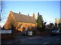
Church of St George the Martyr, Victoria Road, Netherfield
Image: © Richard Vince
Taken: 11 Feb 2014
0.06 miles
3
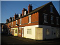
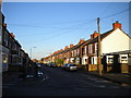
Housing on Cross Street, Gedling
The house at this end of the terrace appears to have been a corner shop in the past.
Image: © Richard Vince
Taken: 11 Feb 2014
0.07 miles
4
Netherfield Cooperative Industrial Society Limited 1895
The decline of this area with the closure of the large railway installations is mirrored in decline in this symbol of a once thriving working class neighbourhood.
Image: © Alan Murray-Rust
Taken: 14 Jan 2007
0.09 miles
7
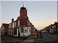
Tower on the corner of Kenrick Street and Chandos Street
Former Ceylon Tea House. The tower once housed a bell.
Image: © Jonathan Thacker
Taken: 7 Dec 2015
0.10 miles
8
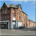
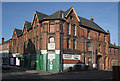
Netherfield Co-operative Industrial Society
This shop, built in 1895 in what was then a mushrooming settlement around the Great Northern Railway's huge Colwick engine shed and marshalling yards, is on the corner of Victoria Road and Dennis Street. Now occupied by Suite Sleep, it looks rather smarter than when Alan Murray-Rust photographed it in January 2007: Image
Image: © John Sutton
Taken: 22 Aug 2013
0.11 miles
9
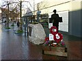
Netherfield War Memorial
Specifically related to World War 1, it was inaugurated as recently as 2019 to mark the centenary of the end of the war in 1919.
Image: © Alan Murray-Rust
Taken: 17 Dec 2020
0.12 miles
10
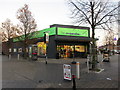
Co-op store, Netherfield
In the centre of the shopping area.
Image: © Jonathan Thacker
Taken: 7 Dec 2015
0.12 miles