IMAGES TAKEN NEAR TO
Ashwell Street, NOTTINGHAM, NG4 2FQ
Introduction
This page details the photographs taken nearby to Ashwell Street, NG4 2FQ by members of the Geograph project.
The Geograph project started in 2005 with the aim of publishing, organising and preserving representative images for every square kilometre of Great Britain, Ireland and the Isle of Man.

There are currently over 7.5m images from over14,400 individuals and you can help contribute to the project by visiting https://www.geograph.org.uk
Image Map
Images are licensed for reuse under creativecommons.org/licenses/by-sa/2.0
Notes
- Clicking on the map will re-center to the selected point.
- The higher the marker number, the further away the image location is from the centre of the postcode.
Image Listing (48 Images Found)
Images are licensed for reuse under creativecommons.org/licenses/by-sa/2.0
Image
Details
Distance
2
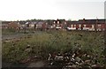
Derelict site close to Netherfield Town Centre
This was the site of Ashwell Street School.
Image: © Jonathan Thacker
Taken: 7 Dec 2015
0.05 miles
3
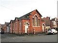
Former chapel, Ashwell Street
Now in commercial use.
Image: © Jonathan Thacker
Taken: 7 Dec 2015
0.06 miles
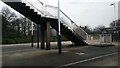
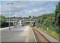
4
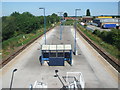
Netherfield railway station
Opened in 1878 by the Great Northern Railway on its line from Grantham to Nottingham. View E towards Grantham, from the approach steps.
Image: © Nigel Thompson
Taken: 24 Jun 2009
0.07 miles
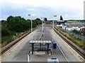
7
On Netherfield Station
The original Great Northern Railway buildings at Netherfield & Colwick were replaced by simpler ones in 1960. Later the station lost its buildings almost entirely, and half of its name. No trains served Netherfield in August 2013 because of the resignalling of Nottingham Midland Station and its approaches. The view is towards Nottingham, with houses in Bakersfield on the skyline.
Image: © John Sutton
Taken: 22 Aug 2013
0.08 miles
8
Netherfield: Meadow Road
Looking towards the junction with Victoria Road, the centre of a settlement which mushroomed in the late 19th century around the huge Colwick engine shed and marshalling yards.
Image: © John Sutton
Taken: 22 Aug 2013
0.09 miles
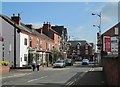
9
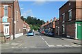
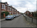
Netherfield: Matlock Street
A typical late-Victorian terraced street in what was from the 1870s to the 1960s predominantly a railway town, built to house the workforce at the huge Colwick loco shed and marshalling yards.
Image: © John Sutton
Taken: 22 Aug 2013
0.09 miles
10
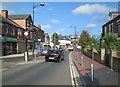
Netherfield: traffic calming in Victoria Road
Near the centre of a suburb which developed round the Great Northern Railway engine shed and marshalling yards in the last quarter of the 19th century.
Image: © John Sutton
Taken: 22 Aug 2013
0.09 miles