IMAGES TAKEN NEAR TO
Kozi Kots, NOTTINGHAM, NG4 2FD
Introduction
This page details the photographs taken nearby to Kozi Kots, NG4 2FD by members of the Geograph project.
The Geograph project started in 2005 with the aim of publishing, organising and preserving representative images for every square kilometre of Great Britain, Ireland and the Isle of Man.

There are currently over 7.5m images from over14,400 individuals and you can help contribute to the project by visiting https://www.geograph.org.uk
Image Map
Images are licensed for reuse under creativecommons.org/licenses/by-sa/2.0
Notes
- Clicking on the map will re-center to the selected point.
- The higher the marker number, the further away the image location is from the centre of the postcode.
Image Listing (60 Images Found)
Images are licensed for reuse under creativecommons.org/licenses/by-sa/2.0
Image
Details
Distance
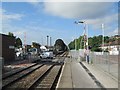
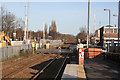
1
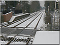
Carlton Station looking towards Nottingham
This station has staggered platforms with a busy level crossing between.
Image: © Alan Murray-Rust
Taken: 2 Feb 2009
0.02 miles
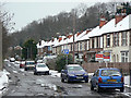
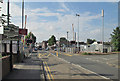
2
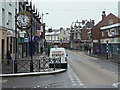
Victoria Street, Netherfield
Local shopping centre still with a variety of shops which have not succumbed entirely to the takeaway/estate agent syndrome.
Image: © Alan Murray-Rust
Taken: 2 Feb 2009
0.04 miles
3
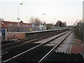
Carlton Station, Nottingham bound platform
The platform for Newark and Lincoln lies to the east of the level crossing.
Image: © Jonathan Thacker
Taken: 7 Dec 2015
0.05 miles
4
Carlton railway station, Nottingham
Opened in 1846 by the Midland Railway on its line from Nottingham to Lincoln. View south west towards Nottingham. Before this name was settled on in 1974, this station had variously been called "Carlton & Gedling" an "Carlton & Netherfield".
Image: © Nigel Thompson
Taken: 24 Jun 2009
0.05 miles
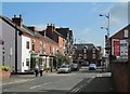
5
Midland Road, Netherfield
This takes its name from the fact that it is alongside what was the Midland railway's line from Nottingham to Lincoln.
Image: © Alan Murray-Rust
Taken: 2 Feb 2009
0.06 miles
6
Netherfield: Meadow Road
Looking towards the junction with Victoria Road, the centre of a settlement which mushroomed in the late 19th century around the huge Colwick engine shed and marshalling yards.
Image: © John Sutton
Taken: 22 Aug 2013
0.06 miles
7
Carlton Station: towards Nottingham
Passengers for Nottingham use the westbound platform on the other side of the level crossing. There were no trains in August 2013 while Nottingham Midland Station and its approaches were resignalled.
Image: © John Sutton
Taken: 22 Aug 2013
0.06 miles
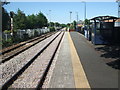
8
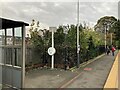
Platform at Carlton Railway Station
Nottingham-bound platform.
Image: © Jonathan Clitheroe
Taken: 2 Nov 2022
0.06 miles
9
A borderline case
The staggered platforms of Carlton Station lie each in one grid square. The boundary between SK6141 and 6241 lies just the far side of the level crossing. Carlton Station (formerly Carlton and Netherfield) is actually in Netherfield, but is called Carlton to distinguish it from Netherfield Station (formerly Netherfield and Colwick) Image
Image: © Alan Murray-Rust
Taken: 14 Jan 2007
0.07 miles
10
Carlton level crossing
The platforms of Carlton station, on the Nottingham-Lincoln line, are staggered, the eastbound platform to the left of the crossing, the westbound to the right. The station was formerly Carlton & Netherfield, to distinguish it from Netherfield & Colwick on the Grantham line. Carlton is behind the camera, Netherfield (a one-time railway town) straight ahead.
Image: © John Sutton
Taken: 22 Aug 2013
0.07 miles