IMAGES TAKEN NEAR TO
River Road, NOTTINGHAM, NG4 2EW
Introduction
This page details the photographs taken nearby to River Road, NG4 2EW by members of the Geograph project.
The Geograph project started in 2005 with the aim of publishing, organising and preserving representative images for every square kilometre of Great Britain, Ireland and the Isle of Man.

There are currently over 7.5m images from over14,400 individuals and you can help contribute to the project by visiting https://www.geograph.org.uk
Image Map
Images are licensed for reuse under creativecommons.org/licenses/by-sa/2.0
Notes
- Clicking on the map will re-center to the selected point.
- The higher the marker number, the further away the image location is from the centre of the postcode.
Image Listing (63 Images Found)
Images are licensed for reuse under creativecommons.org/licenses/by-sa/2.0
Image
Details
Distance
1
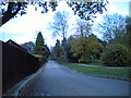
Colwick Country Park access road
The road into the park from Mile End Road.
Image: © Richard Vince
Taken: 16 Nov 2013
0.02 miles
2
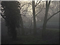
Trent Valley fog at Colwick Park
At 3 in the afternoon, the fog was just beginning to break!
Image: © Alan Murray-Rust
Taken: 23 Dec 2007
0.02 miles
3
Embankment in Colwick Park
A number of embankments in the area have been remodelled, presumably as part of improved flood defence.
Image: © Alan Murray-Rust
Taken: 24 May 2011
0.03 miles
4
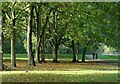
Sunlight in the trees
At the entrance to Colwick Country Park
Image: © Alan Murray-Rust
Taken: 15 Oct 2022
0.03 miles
5
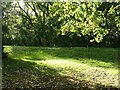
Autumn sunshine
At the entrance to Colwick Country Park
Image: © Alan Murray-Rust
Taken: 15 Oct 2022
0.04 miles
6
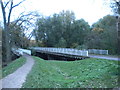
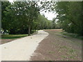
Parallel bridges, Colwick Country Park
Bridges carrying a footpath and a road into Colwick Country Park from Mile End Road.
Image: © Richard Vince
Taken: 16 Nov 2013
0.05 miles
7

Boundary markers at Colwick (1)
This pair of boundary markers share the traditional City of Nottingham shape. It seems clear that the right hand one, marked Carlton UDC, has come from the same source, but I have not seen any other similar ones relating to Carlton. The provision of two markers is in itself quite unusual; the normal procedure would be to create a shared marked with both authorities' names. Also of interest is that the two markers have different dates. The markers would have been installed here as a result of an expansion of the City of Nottingham boundaries in 1933. The Carlton marker is seen unobstructed in this image http://www.geograph.org.uk/photo/2427674 .
Image: © Alan Murray-Rust
Taken: 24 May 2011
0.05 miles
8
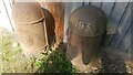
A pair of boundary markers in Colwick Country Park
On the boundary between Carlton UDC and City of Nottingham. There are other views of the markers at Image and Image
The markers have Milestone Society National IDs: NT_NOT03pb (left) and NT_CARL01pb (right)
Image: © Luke Shaw
Taken: 27 Aug 2022
0.05 miles
9
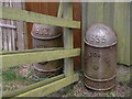
Boundary markers at Colwick (2)
This pair of boundary markers share the traditional City of Nottingham shape. It seems clear that the right hand one, marked Carlton UDC, has come from the same source, but I have not seen any other similar ones relating to Carlton. The provision of two markers is in itself quite unusual; the normal procedure would be to create a shared marked with both authorities' names. Also of interest is that the two markers have different dates. The markers would have been installed here as a result of an expansion of the City of Nottingham boundaries in 1933. The Nottingham marker is seen unobstructed in this image http://www.geograph.org.uk/photo/2427669 .
Image: © Alan Murray-Rust
Taken: 24 May 2011
0.05 miles
10
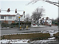
Slow down!
A speed and stop-line camera keeps a watchful eye at the junction of Mile End Road and First Avenue.
Image: © Alan Murray-Rust
Taken: 2 Feb 2009
0.07 miles