IMAGES TAKEN NEAR TO
Campbell Drive, NOTTINGHAM, NG4 1RB
Introduction
This page details the photographs taken nearby to Campbell Drive, NG4 1RB by members of the Geograph project.
The Geograph project started in 2005 with the aim of publishing, organising and preserving representative images for every square kilometre of Great Britain, Ireland and the Isle of Man.

There are currently over 7.5m images from over14,400 individuals and you can help contribute to the project by visiting https://www.geograph.org.uk
Image Map
Images are licensed for reuse under creativecommons.org/licenses/by-sa/2.0
Notes
- Clicking on the map will re-center to the selected point.
- The higher the marker number, the further away the image location is from the centre of the postcode.
Image Listing (34 Images Found)
Images are licensed for reuse under creativecommons.org/licenses/by-sa/2.0
Image
Details
Distance
1
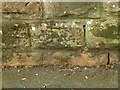
Bench mark on Foxhill Road
A rather scruffy example, cut into the rather friable local sandstone. The location is just at the back of the photographer in this view http://www.geograph.org.uk/photo/3418635
Image: © Alan Murray-Rust
Taken: 22 May 2016
0.06 miles
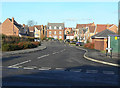
2
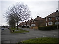
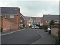
Foxhill Road Central service road, Carlton
The houses on this part of Foxhill Road Central are accessed via a service road that remains level as the main part of the road gradually slopes. Campbell Drive, whose sign is visible, is the side road that continues out of frame to the right.
Image: © Richard Vince
Taken: 13 Apr 2013
0.06 miles
3

Carlton roofscape ? 2
Sheltered housing bungalows on Foxhill Road in the foreground; houses on Fairway Drive beyond.
Image: © Alan Murray-Rust
Taken: 12 Jan 2021
0.08 miles
4
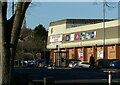
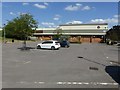
Richard Herrod Centre
Given the current lockdown, I was surprised to see so many cars here, until I got a bit closer http://www.geograph.org.uk/photo/6728761 and discovered the reason.
Image: © Alan Murray-Rust
Taken: 12 Jan 2021
0.09 miles
5
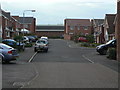
Pitch Close
After your Image, You have to Pitch Close on your Image The names for this development were clearly devised by someone with a sense of humour. The raison d'etre is that the area was formerly a golf driving range.
Image: © Alan Murray-Rust
Taken: 1 Feb 2009
0.10 miles
6
Richard Herrod Centre
The empty car park is a feature of the Covid-19 lockdown period.
Image: © Alan Murray-Rust
Taken: 30 May 2020
0.11 miles
7
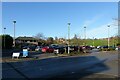
Car Park at Richard Herrod Centre
The centre is being used as a Covid-19 vaccination centre, otherwise the car park would be almost empty.
Image: © Alan Murray-Rust
Taken: 12 Jan 2021
0.12 miles
8
Fairway Drive
This is stage 1. Next you have to Image on your Image The names for this development were clearly devised by someone with a sense of humour. The raison d'etre is that the area was formerly a golf driving range.
Image: © Alan Murray-Rust
Taken: 18 Nov 2008
0.13 miles
9
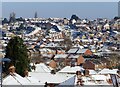
Urban snow in the sunshine
You can see which houses have the better level of loft insulation!
Image: © Alan Murray-Rust
Taken: 25 Jan 2021
0.13 miles
10
Green Approach
After your Image, You have to Image on your Green Approach. The names for this development were clearly devised by someone with a sense of humour. The raison d'etre is that the area was formerly a golf driving range.
Image: © Alan Murray-Rust
Taken: 1 Feb 2009
0.15 miles