IMAGES TAKEN NEAR TO
Greenwood Crescent, NOTTINGHAM, NG4 1AQ
Introduction
This page details the photographs taken nearby to Greenwood Crescent, NG4 1AQ by members of the Geograph project.
The Geograph project started in 2005 with the aim of publishing, organising and preserving representative images for every square kilometre of Great Britain, Ireland and the Isle of Man.

There are currently over 7.5m images from over14,400 individuals and you can help contribute to the project by visiting https://www.geograph.org.uk
Image Map (Loading...)


Getting Data...Please wait
Leaflet Map data © OpenStreetMap
Images are licensed for reuse under creativecommons.org/licenses/by-sa/2.0
Notes
- Clicking on the map will re-center to the selected point.
- The higher the marker number, the further away the image location is from the centre of the postcode.
Image Listing (53 Images Found)
Images are licensed for reuse under creativecommons.org/licenses/by-sa/2.0
Image
Details
Distance
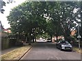
1
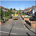
Bakersfield: a delivery at Greenwood Crescent
One of many steep suburban streets on the hilly eastern side of Nottingham.
Image: © John Sutton
Taken: 23 Sep 2015
0.02 miles
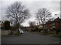
2
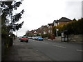
East end of Greenwood Road, Bakersfield
The bus stop on the right is the nominal terminus for Nottingham City Transport route 43, though buses seldom wait there as they serve Bakersfield with a unidirectional loop.
Image: © Richard Vince
Taken: 13 Apr 2013
0.06 miles
3
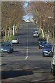
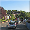
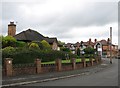
Douglas Avenue
The serrated geography of the eastern suburbs of Nottingham has resulted in many steep roads.
Image: © Alan Murray-Rust
Taken: 14 Jan 2007
0.06 miles
5
Bakersfield: the eastern end of Greenwood Road
The 43 bus is about to turn left into Douglas Avenue and climb to Oakdale Road.
Image: © John Sutton
Taken: 23 Sep 2015
0.07 miles
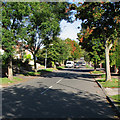
6
Douglas Avenue, Bakersfield
Looking north up Douglas Avenue from its junction with Greenwood Road (left); Douglas Avenue continues for a very short distance behind the photographer before ending abruptly at the railway boundary fence. It is one of the more challenging hills that buses in Nottingham have to face, partly because the hard left turn from Greenwood Road means they always begin the ascent at low speed.
Image: © Richard Vince
Taken: 13 Apr 2013
0.08 miles
7
Bakersfield: up Douglas Avenue
A steep climb for the 43 bus.
Image: © John Sutton
Taken: 23 Sep 2015
0.08 miles
9
Bakersfield: bungalow on Broadway East
The large bungalow on the left was built in 1958-9 by some people who had been our neighbours in Bobbers Mill. I made a sentimental journey to Bakersfield for the first time in fifty years to see where, quite often, I came after school for tea, and did my homework while my mother and Kitty Herries nattered. Autres temps, autres moeurs....
Image: © John Sutton
Taken: 10 May 2012
0.09 miles
10
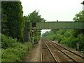
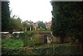
Footbridge at Carlton
This footbridge crosses the rail-line at Carlton, on the edge of Colwick Woods.
Image: © Donnylad
Taken: 2 Jun 2007
0.10 miles