IMAGES TAKEN NEAR TO
Oakdale Road, NOTTINGHAM, NG4 1AD
Introduction
This page details the photographs taken nearby to Oakdale Road, NG4 1AD by members of the Geograph project.
The Geograph project started in 2005 with the aim of publishing, organising and preserving representative images for every square kilometre of Great Britain, Ireland and the Isle of Man.

There are currently over 7.5m images from over14,400 individuals and you can help contribute to the project by visiting https://www.geograph.org.uk
Image Map
Images are licensed for reuse under creativecommons.org/licenses/by-sa/2.0
Notes
- Clicking on the map will re-center to the selected point.
- The higher the marker number, the further away the image location is from the centre of the postcode.
Image Listing (33 Images Found)
Images are licensed for reuse under creativecommons.org/licenses/by-sa/2.0
Image
Details
Distance
1
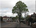
A grey May morning on Oakdale Road
Looking towards the church of St John the Baptist, which dates from 1957.
Image: © John Sutton
Taken: 10 May 2012
0.02 miles
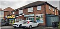
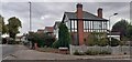
2
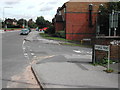
Junction Douglas Ave/ Oakdale Road, Carlton, Nottingham
Image: © Tom Courtney
Taken: 26 Aug 2005
0.02 miles
3
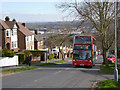
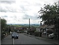
Climbing Douglas Avenue
The topology of the high ground to the east of Nottingham abounds with steep sided valleys, with a consequent effect on the road network. This particular bus route is prone to disruption during snowfall or icy conditions.
Image: © Alan Murray-Rust
Taken: 16 Mar 2014
0.04 miles
4
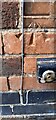
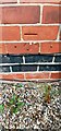
Benchmark on side of jut on NW face of #246 Oakdale Road
Ordnance Survey cut mark benchmark levelled at 73.484m above Newlyn Datum verified 1962
Image: © Roger Templeman
Taken: 26 Sep 2022
0.07 miles
5
Nos. 248 and 246 Oakdale Road
#248 is Jazz's Convenience Store, #246 Remedy Health & Beauty Treatments. There is an Ordnance Survey benchmark Image on the near corner, right hand face, of #246.
Image: © Roger Templeman
Taken: 26 Sep 2022
0.07 miles
6
Bakersfield: Broadway East and beyond
The hilly eastern side of Nottingham drops steeply down to the broad Trent Valley, so from Bakersfield and elsewhere there are wide views over the river to the distant wolds, and further east the Vale of Belvoir.
Image: © John Sutton
Taken: 10 May 2012
0.07 miles
7
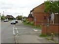
Junction Douglas Ave/ Oakdale Road, Carlton, Nottingham
Recreating this 'First' for the square https://www.geograph.org.uk/photo/43300 . The house on the right has lost its odd projecting windows, and the street name sign in the foreground has disappeared.
Image: © Alan Murray-Rust
Taken: 23 May 2021
0.08 miles
8
Benchmark on chimney breast of #216 Oakdale Road
Ordnance Survey cut mark benchmark levelled at 75.801m above Newlyn Datum verified 1962
Image: © Roger Templeman
Taken: 26 Sep 2022
0.09 miles
9
Houses on Oakdale Road at Poplar Close junction
There is an Ordnance Survey benchmark Image on the chimney breast of the nearest house
Image: © Roger Templeman
Taken: 26 Sep 2022
0.09 miles
10
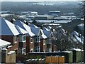
Trent Valley under snow
View from Douglas Avenue with Colwick Industrial Estate in the middle distance.
Image: © Alan Murray-Rust
Taken: 25 Jan 2021
0.09 miles