IMAGES TAKEN NEAR TO
Yarwell Close, NOTTINGHAM, NG3 7HF
Introduction
This page details the photographs taken nearby to Yarwell Close, NG3 7HF by members of the Geograph project.
The Geograph project started in 2005 with the aim of publishing, organising and preserving representative images for every square kilometre of Great Britain, Ireland and the Isle of Man.

There are currently over 7.5m images from over14,400 individuals and you can help contribute to the project by visiting https://www.geograph.org.uk
Image Map
Images are licensed for reuse under creativecommons.org/licenses/by-sa/2.0
Notes
- Clicking on the map will re-center to the selected point.
- The higher the marker number, the further away the image location is from the centre of the postcode.
Image Listing (51 Images Found)
Images are licensed for reuse under creativecommons.org/licenses/by-sa/2.0
Image
Details
Distance
1
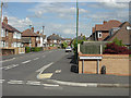
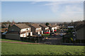
Northdale Road
Virtually the roads in this area incorporate -dale in their name. This is Northdale Road seen from Sunnydale Road. The whole area is typical tween-wars suburbia.
Image: © Alan Murray-Rust
Taken: 20 Jun 2008
0.09 miles

3
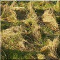
Grass tussocks
In a steep corner of Carlton Recreation Ground.
Image: © Alan Murray-Rust
Taken: 25 Dec 2020
0.11 miles
4
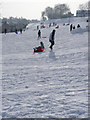
On the piste
The landscaped slopes of the former brickyard, now Carlton Hill Recreation Ground, are ideal for tobogganing, especially when the snow is powdery. There was even one young lady on skis.
Image: © Alan Murray-Rust
Taken: 5 Feb 2012
0.13 miles
5
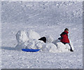
Snow castle
The first snowfall of the winter provides plenty of enjoyment.
Image: © Alan Murray-Rust
Taken: 5 Feb 2012
0.14 miles
6
Steinbeck Road, Carlton
Housing development on the site of a former brick works. The steep slopes result from the quarrying of the clay.
Image: © Alan Murray-Rust
Taken: 14 Jan 2007
0.14 miles
7
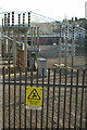
Switching station, Carlton
This is a major local switching station, entirely surrounded by residential properties.
Image: © Alan Murray-Rust
Taken: 14 Jan 2007
0.14 miles
8
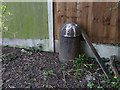
Carlton U D C boundary post
One of a pair (see http://www.geograph.org.uk/photo/3902681) at the southern end of the Carlton Hill Recreation Ground. The post is the same design as those of Nottingham City Council, who share this boundary. Although the boundary was established in 1933 when parts of Carlton were taken into the city, the Carlton posts are for some reason dated 1935. See http://www.geograph.org.uk/photo/3902733 for location.
Image: © Alan Murray-Rust
Taken: 16 Mar 2014
0.14 miles
9
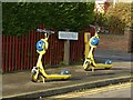
No-one's gone with the Wind
Hireable scooters waiting for customers. Wind electric scooters are an initiative by Nottingham City Council – available for hire via an app on your smartphone.
Image: © Alan Murray-Rust
Taken: 25 Dec 2020
0.15 miles
10
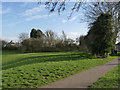
The southern end of the Carlton Hill Recreation Ground
Showing the location of the boundary posts seen here http://www.geograph.org.uk/photo/3902680 http://www.geograph.org.uk/photo/3902681. The boundary between Nottingham City (right) and Gedling Borough (left) follows the line of trees on the right, then turns 90 degrees along the fence in the centre, then again at the left end of the fence. The posts are respectively at the right hand and left hand angles described. A third marker is shown on maps at the next corner, near the foot of the left hand conifers, but there is no sign of it.
Image: © Alan Murray-Rust
Taken: 16 Mar 2014
0.15 miles