IMAGES TAKEN NEAR TO
Greenwood Avenue, NOTTINGHAM, NG3 7FX
Introduction
This page details the photographs taken nearby to Greenwood Avenue, NG3 7FX by members of the Geograph project.
The Geograph project started in 2005 with the aim of publishing, organising and preserving representative images for every square kilometre of Great Britain, Ireland and the Isle of Man.

There are currently over 7.5m images from over14,400 individuals and you can help contribute to the project by visiting https://www.geograph.org.uk
Image Map
Images are licensed for reuse under creativecommons.org/licenses/by-sa/2.0
Notes
- Clicking on the map will re-center to the selected point.
- The higher the marker number, the further away the image location is from the centre of the postcode.
Image Listing (35 Images Found)
Images are licensed for reuse under creativecommons.org/licenses/by-sa/2.0
Image
Details
Distance
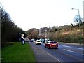
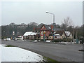
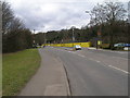
2
Ascending Greenwood Road, Bakersfield
Like many roads in Nottingham's eastern suburbs, Greenwood Road is subject to steep inclines. The public footpath (whose sign is visible on the extreme left) leads into Colwick Woods.
Image: © Richard Vince
Taken: 13 Apr 2013
0.09 miles
3
Bakersfield: up Greenwood Road
The eastern side of Nottingham is hilly. Greenwood Road climbs 40m/131ft in about a third of a mile.
Image: © John Sutton
Taken: 23 Sep 2015
0.10 miles
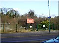
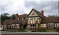
4
Colwick Park Inn
Roadside style public house turned pub/restaurant. The building itself sits squarely across the boundary of the City of Nottingham. The sharp cliff scarp behind marks the edge of the alluvial plain of the River Trent, where at some stage it has cut into the soft sedimentary mudstones.
Image: © Alan Murray-Rust
Taken: 2 Feb 2009
0.11 miles
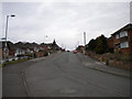
6
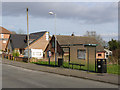
Semi-redundant bus shelter
After Nottingham City Transport converted its local main service to run unidirectionally via Greenwood Road and Douglas Avenue, the only service to use this stop is a shopping service which provides a single journey on 2 days of the week only.
Image: © Alan Murray-Rust
Taken: 16 Mar 2014
0.12 miles
7
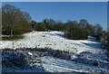
Clearing in Colwick Woods Park
By this time the sun had removed the snow from the branches – compare with http://www.geograph.org.uk/photo/6740820
Image: © Alan Murray-Rust
Taken: 25 Jan 2021
0.12 miles
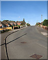
9
Sharp bend in Greenwood Road, Bakersfield
Travelling west, as Greenwood Road crosses into Nottingham it dips and then bends sharply near the eastern extremity of Colwick Woods. From this distance the angle of the bend looks very similar to the angle on the warning sign. The main bus service here, Nottingham City Transport route 43, serves this part of Bakersfield with a unidirectional loop, meaning that the bus shelter just before the bend is now virtually disused (according to the timetable on the bus stop, it gets two buses a week).
Image: © Richard Vince
Taken: 13 Apr 2013
0.13 miles