IMAGES TAKEN NEAR TO
Oakdale Road, NOTTINGHAM, NG3 7EH
Introduction
This page details the photographs taken nearby to Oakdale Road, NG3 7EH by members of the Geograph project.
The Geograph project started in 2005 with the aim of publishing, organising and preserving representative images for every square kilometre of Great Britain, Ireland and the Isle of Man.

There are currently over 7.5m images from over14,400 individuals and you can help contribute to the project by visiting https://www.geograph.org.uk
Image Map
Images are licensed for reuse under creativecommons.org/licenses/by-sa/2.0
Notes
- Clicking on the map will re-center to the selected point.
- The higher the marker number, the further away the image location is from the centre of the postcode.
Image Listing (42 Images Found)
Images are licensed for reuse under creativecommons.org/licenses/by-sa/2.0
Image
Details
Distance
1
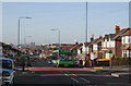
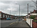
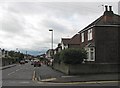
Oakdale Road, Bakersfield, Nottingham
A typical view of British surburbia from the period between the two World Wars.
It shows the quite hilly nature of the eastern side of Nottingham, with the City Centre in the distance. Despite the OS 1:25000 showing the area as Bakers Fields, it is commonly known as Bakersfield, as shown on the bus destination.
Image: © Alan Murray-Rust
Taken: 14 Jan 2007
0.01 miles
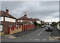
2
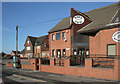
Drink and get well
The Tally Ho and Bakersfield Medical Centre, Oakdale Road, Nottingham
The area is normally known to locals as Bakersfield, despite the OS reference to Bakers Fields.
Image: © Alan Murray-Rust
Taken: 14 Jan 2007
0.04 miles
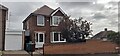
3
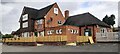
The Bakersfield, formerly Tally Ho public house on north side of Oakdale Road
There is an Ordnance Survey benchmark Image on the wall on the left hand side of the ramp to the function room
Image: © Roger Templeman
Taken: 26 Sep 2022
0.05 miles
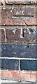
4
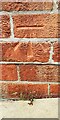
Benchmark on The Bakersfield pub, Oakdale Road
Ordnance Survey cut mark benchmark levelled at 83.436m above Newlyn Datum verified 1962
Image: © Roger Templeman
Taken: 26 Sep 2022
0.06 miles
5
Bakersfield: Oakdale Road
Oakdale Road is an extension of Sneinton Dale, developed in the 1930s as the city expanded eastwards. This is the view down the hill towards the city centre.
Image: © John Sutton
Taken: 10 May 2012
0.06 miles
6
Bakersfield: the corner of Oakdale and Greendale Roads
Houses built in the 1930s as the city expanded eastwards into the hills north of Colwick Woods.
Image: © John Sutton
Taken: 10 May 2012
0.06 miles
7
Benchmark on NW angle of #37 Greendale Road
Ordnance Survey cut mark benchmark levelled at 79.669m above Newlyn Datum verified 1962
Image: © Roger Templeman
Taken: 26 Sep 2022
0.06 miles
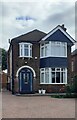
8
#37 Greendale Road
There is an Ordnance Survey benchmark Image on the left hand side of the house at its front corner
Image: © Roger Templeman
Taken: 26 Sep 2022
0.07 miles
9
Bakersfield: Greendale Road
Part of the inter-wars eastward expansion of the city. This is the hillier part of Nottingham (about 85m/278ft above sea level here), with views southwards over the Trent Valley to the Vale of Belvoir.
Image: © John Sutton
Taken: 10 May 2012
0.08 miles
10
#5 Greendale Road
There is an Ordnance Survey benchmark Image on the left hand side of the house at its front corner
Image: © Roger Templeman
Taken: 26 Sep 2022
0.08 miles