IMAGES TAKEN NEAR TO
Greenwood Road, NOTTINGHAM, NG3 7EA
Introduction
This page details the photographs taken nearby to Greenwood Road, NG3 7EA by members of the Geograph project.
The Geograph project started in 2005 with the aim of publishing, organising and preserving representative images for every square kilometre of Great Britain, Ireland and the Isle of Man.

There are currently over 7.5m images from over14,400 individuals and you can help contribute to the project by visiting https://www.geograph.org.uk
Image Map
Images are licensed for reuse under creativecommons.org/licenses/by-sa/2.0
Notes
- Clicking on the map will re-center to the selected point.
- The higher the marker number, the further away the image location is from the centre of the postcode.
Image Listing (27 Images Found)
Images are licensed for reuse under creativecommons.org/licenses/by-sa/2.0
Image
Details
Distance
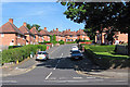
1
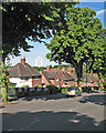
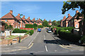
Greenwood Road
Council houses on the hilly eastern side of Nottingham, with the Windmill Lane tower block in the distance.
Image: © John Sutton
Taken: 4 Jul 2016
0.03 miles
2
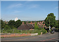
A long view from Greenwood Road
Looking across Sneinton and St Ann's from near the top of Greenwood Road on the hilly eastern side of Nottingham.
Image: © John Sutton
Taken: 4 Jul 2016
0.05 miles
3
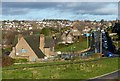
View towards Thorneywood
From the western end of Colwick Woods park. Left foreground is the former Greenwood Tree pub (later The Inn on the Hill) which has now been empty for several years.
Image: © Alan Murray-Rust
Taken: 26 Dec 2017
0.09 miles
4
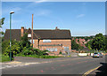
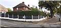
Closed pub on Greenwood Road
The boarded-up building was once the Inn on the Hill.
Image: © John Sutton
Taken: 4 Jul 2016
0.10 miles
5
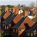
Red brick, red tiles
The splayed eaves and central chimney stacks are distinctive features of Nottingham's council houses of the inter-war and early post-war periods.
Image: © Alan Murray-Rust
Taken: 26 Dec 2017
0.10 miles
6
#337 Sneinton Dale at Hemswell Close junction
Ordnance Survey documents indicate that a benchmark levelled at 49.743m above Newlyn Datum was verified in 1962 on the west angle of the house
Image: © Roger Templeman
Taken: 26 Sep 2022
0.10 miles
7
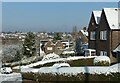
Snowy suburbia
On Greenwood Road at the western end of Bakersfield.
Image: © Alan Murray-Rust
Taken: 25 Jan 2021
0.10 miles
8
Sneinton Dale: up Skipton Circus
Nottingham built council houses in Garden City style all over the city. The right-hand street name is the cream-painted cast-iron circle once universal in the city's estates, but the one on the left is a modern replacement. The picture gives some idea of the hilliness of the eastern suburbs.
Image: © John Sutton
Taken: 4 Jul 2016
0.15 miles
9
Sneinton Dale: Ipswich Circus
Nottingham built council houses in Garden City style all over the city.
Image: © John Sutton
Taken: 4 Jul 2016
0.16 miles
10
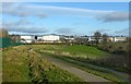
In Colwick Woods Park
Looking towards the Nottingham Basketball Arena (the large sheds to the left) and the Nottingham Academy (towards the right).
Image: © Alan Murray-Rust
Taken: 26 Dec 2017
0.18 miles