IMAGES TAKEN NEAR TO
Conifer Walk, NOTTINGHAM, NG3 6NN
Introduction
This page details the photographs taken nearby to Conifer Walk, NG3 6NN by members of the Geograph project.
The Geograph project started in 2005 with the aim of publishing, organising and preserving representative images for every square kilometre of Great Britain, Ireland and the Isle of Man.

There are currently over 7.5m images from over14,400 individuals and you can help contribute to the project by visiting https://www.geograph.org.uk
Image Map
Images are licensed for reuse under creativecommons.org/licenses/by-sa/2.0
Notes
- Clicking on the map will re-center to the selected point.
- The higher the marker number, the further away the image location is from the centre of the postcode.
Image Listing (30 Images Found)
Images are licensed for reuse under creativecommons.org/licenses/by-sa/2.0
Image
Details
Distance
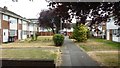
1
Bramblewood Estate
Built on the site of a former brickworks. The ground level would originally have run through from where the photograph was taken to the houses on the horizon, giving some idea of the amount of material that was extracted to make bricks. The whole of this hilly area to the east of Nottingham is basically a large lump of clay in the form of soft mudstones and siltstones. The pub on the estate was built round a steam engine which powered the presses and other machinery. This engine has since been removed to the Wollaton Industrial Museum.
Image: © Alan Murray-Rust
Taken: 27 Jan 2008
0.05 miles
2
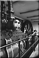
The Engine House public house, Burgass Road
This public house was built on the site of The Nottingham Patent Brick Company (see -Image) and incorporated this rather large and old horizontal single cylinder steam engine. This was possibly c1850 and installed secondhand in 1868 and worked here for 98 years - a very creditable performance. The cylinder is 21" bore x 66" stroke and the flywheel is 16' diameter and had been adapted for rope drive. The engine was removed from the pub in 1982 and is being slowly re-erected at Nottingham Industrial Museum.
Image: © Chris Allen
Taken: 1 Mar 1981
0.08 miles
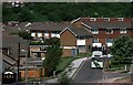
3
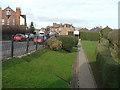
Brick Kiln Way
This footpath leads down to the housing development which can be seen immediately above the railings. This sunken area was formerly completely occupied by a brickworks which has completely removed the hillside. The name of the path retains the link to the former industry
Image: © Alan Murray-Rust
Taken: 27 Jan 2008
0.09 miles
4
Honeywood Court
Pleasant little group of houses between Honeywood Drive and Galena Drive
Image: © David Lally
Taken: 13 Jul 2018
0.12 miles
5
Bus in the Brickyard Estate, Thorneywood – 1986
In the run-up to the deregulation of bus services in October 1986, City of Nottingham Transport introduced a series of ‘Accessline’ services using small buses to reach areas that could not be served by full size buses. The idea was that these areas would not be attractive to possible competitors after deregulation and that passengers would be attracted to use these localised services rather than walk to main roads. These services were never economically viable and in most cases, including this route, services were withdrawn soon after deregulation and have not been replaced since.
Image: © Alan Murray-Rust
Taken: 1 May 1986
0.12 miles
6
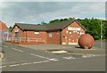
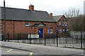
The Brickyard Community Centre
The brickyard estate was built inside the quarry area of the Thorneywood Brickworks. The ball http://www.geograph.org.uk/photo/4963392 seems to be quite a recent addition.
Image: © Alan Murray-Rust
Taken: 23 May 2016
0.13 miles
7
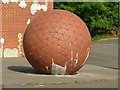
Big brick ball
You will need a large brickbat to hit it! Outside the Brickyard Community Centre, see http://www.geograph.org.uk/photo/4963378
Image: © Alan Murray-Rust
Taken: 23 May 2016
0.13 miles
8
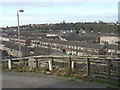
Standhill Road
The entrance to King George V Playing Field. The way the ground falls steeply to the right hand side can be clearly seen, and there is a similar fall on the other side of the road. This is due to the excavation of clays on both sides of the road for brickmaking, leaving it as a high embankment.
Image: © Alan Murray-Rust
Taken: 27 Jan 2008
0.14 miles
9
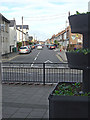
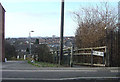
Standhill Road
Looking along this street from Carlton Hill. Typical terraced housing from around the end of the 19th century. The planter is part of the modernisation of the local shopping area.
Image: © Alan Murray-Rust
Taken: 27 Jan 2008
0.14 miles