IMAGES TAKEN NEAR TO
City View, NOTTINGHAM, NG3 6DE
Introduction
This page details the photographs taken nearby to City View, NG3 6DE by members of the Geograph project.
The Geograph project started in 2005 with the aim of publishing, organising and preserving representative images for every square kilometre of Great Britain, Ireland and the Isle of Man.

There are currently over 7.5m images from over14,400 individuals and you can help contribute to the project by visiting https://www.geograph.org.uk
Image Map
Images are licensed for reuse under creativecommons.org/licenses/by-sa/2.0
Notes
- Clicking on the map will re-center to the selected point.
- The higher the marker number, the further away the image location is from the centre of the postcode.
Image Listing (26 Images Found)
Images are licensed for reuse under creativecommons.org/licenses/by-sa/2.0
Image
Details
Distance
1
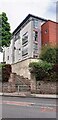
Franklin House on SW side of Porchester Road
There is an Ordnance Survey cut mark benchmark Image on the roadside wall about 8 feet right of the steps
Image: © Roger Templeman
Taken: 10 May 2022
0.10 miles
2
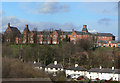
Mapperley Hospital, Male Wing
Opened in 1880 as the Nottingham Borough Asylum, and closed as a hospital in 1994. Parts are still in use as a Psychiatric Unit, but this wing has been converted into apartments.
Image: © Alan Murray-Rust
Taken: 8 Mar 2009
0.10 miles
3
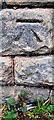
Benchmark on stone in wall on SW side of Porchester Road opposite #288
Ordnance Survey cut mark benchmark levelled at 112.371m above Newlyn Datum in 1962
Image: © Roger Templeman
Taken: 10 May 2022
0.10 miles
4
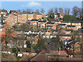
View across the Wells Road
The white houses are the original development on The Wells Road, with the nearer development being relatively recent. The skyline is dominated by Mapperley Hospital.
Image: © Alan Murray-Rust
Taken: 8 Mar 2009
0.11 miles
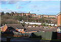
5
Housing between The Wells Road and Porchester Road
1990s infill housing on a steep hillside that had remained undeveloped.
Image: © Alan Murray-Rust
Taken: 8 Mar 2009
0.11 miles
6
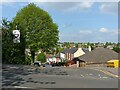
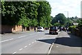
How good are your hill starts?
As well as having to take care of the gradient (about 1 in 6), you have to find your way into the generally heavy traffic on Porchester Road.
Image: © Alan Murray-Rust
Taken: 27 May 2021
0.12 miles
7
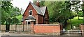
Lodge and entrance to City Heights Greenspace woodland on NE side of The Wells Road
Ordnance Survey documents indicate that a benchmark was levelled at 96.488m above Newlyn Datum in 1962 on the wall in the centre of the image. The wall appears to have been rebuilt.
Image: © Roger Templeman
Taken: 10 May 2022
0.12 miles
8
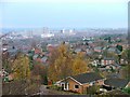
View from Porchester Road Towards the City
The tower blocks around the Victoria Centre dominate the view. To the left, nicely framed by two cranes the dome of the Council House can be seen.
Image: © Mick Garratt
Taken: 3 Dec 2005
0.13 miles
9
The Wells Road
Looking downhill towards the city centre.
Image: © David Lally
Taken: 5 Jul 2016
0.14 miles
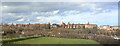
10
Panorama of Mapperley Hospital
This was opened in 1880 as the Nottingham Borough Asylum, and "You'll end up in Mapperley" was common local usage when anyone acted strangely. It closed as a mental hospital in 1994, although a large part is still used by the NHS.
The buildings are strung out along a ridge and can be seen to advantage from this location. The main left hand wing was the female wing, with the superintendents dwelling next to it. This part is now Duncan Macmillan House, which includes a psychiatric unit and training facilities. Further right is the chapel, and the main right hand wing was the male wing. This has now been converted into apartments, together with the new buildings at the right hand side of the picture.
The buildings were designed by G.T.Hine, son of the architect of the nearby Coppice Hospital. Hine's work at Mapperley launcehed him as consultant architect to H.M. Commissioners for Lunacy. (source: Pevsner, Nottinghamshire)
Image: © Alan Murray-Rust
Taken: 8 Mar 2009
0.14 miles