IMAGES TAKEN NEAR TO
Kent Road, NOTTINGHAM, NG3 6BG
Introduction
This page details the photographs taken nearby to Kent Road, NG3 6BG by members of the Geograph project.
The Geograph project started in 2005 with the aim of publishing, organising and preserving representative images for every square kilometre of Great Britain, Ireland and the Isle of Man.

There are currently over 7.5m images from over14,400 individuals and you can help contribute to the project by visiting https://www.geograph.org.uk
Image Map
Images are licensed for reuse under creativecommons.org/licenses/by-sa/2.0
Notes
- Clicking on the map will re-center to the selected point.
- The higher the marker number, the further away the image location is from the centre of the postcode.
Image Listing (10 Images Found)
Images are licensed for reuse under creativecommons.org/licenses/by-sa/2.0
Image
Details
Distance
1
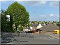
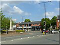
How good are your hill starts?
As well as having to take care of the gradient (about 1 in 6), you have to find your way into the generally heavy traffic on Porchester Road.
Image: © Alan Murray-Rust
Taken: 27 May 2021
0.22 miles
2
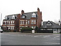
Woodthorpe Road, Mapperley
Substantial semidetached houses across the road [B684] from the Texaco fuel station and Co-operative shop.
Image: © M J Richardson
Taken: 2 Jan 2016
0.23 miles
3
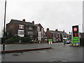
Houses on Woodborough Road
Suburban Nottingham from a petrol station. Looking across the B684.
Image: © M J Richardson
Taken: 2 Jan 2016
0.23 miles
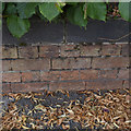
4

Benchmark on stone in wall on SW side of Porchester Road opposite #288
Ordnance Survey cut mark benchmark levelled at 112.371m above Newlyn Datum in 1962
Image: © Roger Templeman
Taken: 10 May 2022
0.23 miles
5
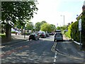
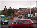
Porchester Road, Nottingham
Recreating this 'First' for the square http://www.geograph.org.uk/photo/39355
Image: © Alan Murray-Rust
Taken: 27 May 2021
0.23 miles
6
Nottingham - NG3
The entrance to "Duncan Macmillan House" from Porchester Road. This is the last remaining (operational) section of Mapperley Hospital and it was named after the last Medical Superintendent of this huge psychiatric hospital.
Image: © David Hallam-Jones
Taken: 21 Apr 2012
0.24 miles
7
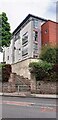
Franklin House on SW side of Porchester Road
There is an Ordnance Survey cut mark benchmark Image on the roadside wall about 8 feet right of the steps
Image: © Roger Templeman
Taken: 10 May 2022
0.24 miles
8
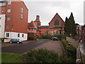
Nottingham - NG3
On the right-hand side of this fence is one of the internal roads of the now defunct Mapperley psychiatric hospital seen passing the side of part of Duncan Macmillan House, the only section of the hospital still providing mental health services. Behind the black car on the left-hand side of the fence one of the end elevations of the derelict hospital church can be seen. The older building to the left of the church is "Nightingale House" on Ockbrook Drive, a part of this Victorian hospital that has been converted into modern apartments. Complementing this older section of the former hospital one of several new apartment blocks are also apparent.
Image: © David Hallam-Jones
Taken: 21 Apr 2012
0.25 miles
9
City Boundary
Recreating this 'First' for the square http://www.geograph.org.uk/photo/39357 . The boundary post can be seen just to the left of the war memorial.
Image: © Alan Murray-Rust
Taken: 27 May 2021
0.25 miles
10
Bench Mark, Woodborough Road
On the wall surrounding Mapperley Reservoir.
Image: © Alan Murray-Rust
Taken: 30 Jul 2014
0.25 miles