IMAGES TAKEN NEAR TO
Hilton Road, NOTTINGHAM, NG3 6AP
Introduction
This page details the photographs taken nearby to Hilton Road, NG3 6AP by members of the Geograph project.
The Geograph project started in 2005 with the aim of publishing, organising and preserving representative images for every square kilometre of Great Britain, Ireland and the Isle of Man.

There are currently over 7.5m images from over14,400 individuals and you can help contribute to the project by visiting https://www.geograph.org.uk
Image Map
Images are licensed for reuse under creativecommons.org/licenses/by-sa/2.0
Notes
- Clicking on the map will re-center to the selected point.
- The higher the marker number, the further away the image location is from the centre of the postcode.
Image Listing (30 Images Found)
Images are licensed for reuse under creativecommons.org/licenses/by-sa/2.0
Image
Details
Distance
1
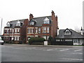
Woodthorpe Road, Mapperley
Substantial semidetached houses across the road [B684] from the Texaco fuel station and Co-operative shop.
Image: © M J Richardson
Taken: 2 Jan 2016
0.15 miles
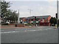
2
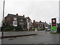
Houses on Woodborough Road
Suburban Nottingham from a petrol station. Looking across the B684.
Image: © M J Richardson
Taken: 2 Jan 2016
0.16 miles
3
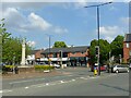
City Boundary
Recreating this 'First' for the square http://www.geograph.org.uk/photo/39357 . The boundary post can be seen just to the left of the war memorial.
Image: © Alan Murray-Rust
Taken: 27 May 2021
0.18 miles
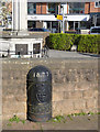
4
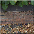
Bench Mark, Woodborough Road
On the wall surrounding Mapperley Reservoir.
Image: © Alan Murray-Rust
Taken: 30 Jul 2014
0.18 miles
5
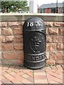
Boundary Marker
at the top of Woodthorpe Drive and marking the boundary between the City of Nottingham and Arnold Town
Image: © Tom Courtney
Taken: 18 Aug 2005
0.18 miles
6
City Boundary
At the junction of Woodthorpe Drive and Woodborough Road. To the right is Nottingham to the left Arnold. The black boundary post is slightly left of centre.
Image: © Tom Courtney
Taken: 18 Aug 2005
0.18 miles
7

Mapperley War Memorial ? detail
Commemorative bronze plaques and ornate cast iron railings. Listed Grade II.
Image: © Alan Murray-Rust
Taken: 27 May 2021
0.18 miles
8
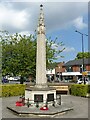
Mapperley War Memorial
Memorial column of Portland stone, erected c.1919. The commemorative panels do not specify the area from which those commemorated originated. Listed Grade II.
Image: © Alan Murray-Rust
Taken: 27 May 2021
0.18 miles
9

Boundary Marker, Woodthorpe Drive Top
This marker is not quite in its original position as the junction between Woodthorpe Drive and Plains Road has been remodelled. Listed Grade II. See also http://www.geograph.org.uk/photo/3938696
Image: © Alan Murray-Rust
Taken: 16 Apr 2014
0.19 miles
10
Boundary Marker, Woodthorpe Drive Top
This marker is not quite in its original position as the junction between Woodthorpe Drive and Plains Road has been remodelled. Listed Grade II. See also http://www.geograph.org.uk/photo/3938698
Image: © Alan Murray-Rust
Taken: 16 Apr 2014
0.19 miles